IMAGES TAKEN NEAR TO
Eriskay Place, GLASGOW, G60 5AS
Introduction
This page details the photographs taken nearby to Eriskay Place, G60 5AS by members of the Geograph project.
The Geograph project started in 2005 with the aim of publishing, organising and preserving representative images for every square kilometre of Great Britain, Ireland and the Isle of Man.

There are currently over 7.5m images from over14,400 individuals and you can help contribute to the project by visiting https://www.geograph.org.uk
Image Map
Images are licensed for reuse under creativecommons.org/licenses/by-sa/2.0
Notes
- Clicking on the map will re-center to the selected point.
- The higher the marker number, the further away the image location is from the centre of the postcode.
Image Listing (48 Images Found)
Images are licensed for reuse under creativecommons.org/licenses/by-sa/2.0
Image
Details
Distance
1
Old Dalnottar Cemetery
This is a view from near the south-western extremity of the cemetery. Click on the end-note title for related images.
Image: © Lairich Rig
Taken: 11 Mar 2014
0.04 miles
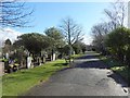
2

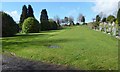
Old Dalnottar Cemetery
This is the central avenue of the cemetery. Click on the end-note title for related images.
Image: © Lairich Rig
Taken: 10 Mar 2014
0.06 miles
3

Housing on Oronsay Crescent
In Old Kilpatrick.
Image: © Stephen Sweeney
Taken: 16 Jan 2008
0.07 miles
4
Clydebank Blitz Memorial: detail
See Image for the whole memorial, and for further information.
Image: © Lairich Rig
Taken: 10 Mar 2014
0.10 miles
5
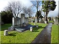
Clydebank Blitz Memorial
See Image for a closer look, and for more information. The present picture is intended to show the memorial in context. The cemetery's central avenue is visible behind it: Image
Image: © Lairich Rig
Taken: 10 Mar 2014
0.10 miles
6
Clydebank Blitz Memorial
See Image for a closer view, and for more information.
Image: © Lairich Rig
Taken: 10 Mar 2014
0.10 miles
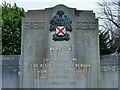
7
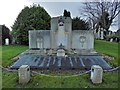
Clydebank Blitz Memorial
"Dedicated to the memory of the citizens of Clydebank who lost their lives through enemy action in March 1941."
The large stone structure is the original memorial. The bronze memorial plaques are the work of local artist Tom McKendrick, and were added in 2009, on the occasion of the re-dedication (see below).
Beneath the roll of names: "This monument is dedicated to those who lost their lives in Clydebank on the 13th and 14th of March 1941 due to the action of enemy bombers. Twenty-two unidentified citizens are interred in this grave. This monument, with the names of those known to have perished, was re-dedicated on 14th March 2009 by Provost Denis Agnew on behalf of West Dunbartonshire Council."
Image: © Lairich Rig
Taken: 10 Mar 2014
0.10 miles
8
Old Dalnottar Cemetery
This is a general view from the path alongside the north-western boundary. Click on the end-note title for related images.
Image: © Lairich Rig
Taken: 11 Mar 2014
0.10 miles
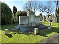
9
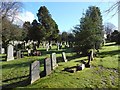
Old Dalnottar Cemetery
This area contains unmarked graves: a communal burial took place here for victims of the Clydebank Blitz of 1941. The Image is located nearby.
Image: © Lairich Rig
Taken: 10 Mar 2014
0.10 miles
10

Old Dalnottar Cemetery Offices
The offices are in the white building at the far end of the path, at the northern corner of the cemetery's boundary. The intervening glasshouses were not an original feature of the cemetery, but were erected before the Second World War.
Image: © Lairich Rig
Taken: 11 Mar 2014
0.11 miles