IMAGES TAKEN NEAR TO
Bowling, GLASGOW, G60 5AB
Introduction
This page details the photographs taken nearby to G60 5AB by members of the Geograph project.
The Geograph project started in 2005 with the aim of publishing, organising and preserving representative images for every square kilometre of Great Britain, Ireland and the Isle of Man.

There are currently over 7.5m images from over14,400 individuals and you can help contribute to the project by visiting https://www.geograph.org.uk
Image Map
Images are licensed for reuse under creativecommons.org/licenses/by-sa/2.0
Notes
- Clicking on the map will re-center to the selected point.
- The higher the marker number, the further away the image location is from the centre of the postcode.
Image Listing (131 Images Found)
Images are licensed for reuse under creativecommons.org/licenses/by-sa/2.0
Image
Details
Distance
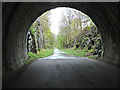
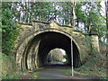
1
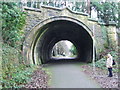
Former Railway Tunnel
The trackbed of the Lanarkshire & Dunbartonshire Railway is now used as the Clyde and Loch Lomond Cycleway; part of route 7.
Image: © Tim Glover
Taken: 31 Dec 2007
0.03 miles
2
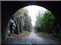
National Cycle Network Route 7
Looking out of the eastern portal of the tunnel to the former trackbed of the Lanarkshire & Dunbartonshire Railway at Bowling. This is now used as the Clyde and Loch Lomond Cycleway; part of route 7.
Image: © Tim Glover
Taken: 31 Dec 2007
0.03 miles
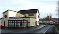
3
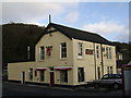
The Railway Inn, Bowling
Bowling's better known watering hole.
Image: © Stephen Sweeney
Taken: 4 Jan 2006
0.04 miles
4
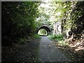
Tunnel, Caledonian and Dunbartonshire Junction Railway
A deep cutting and tunnel above Bowling. The trackbed is now used for a cycle path.
Image: © Richard Webb
Taken: 1 Sep 2009
0.04 miles
5
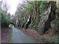
Rock buttresses
On the former Lanarkshire & Dunbartonshire Railway line through Bowling.
Image: © Thomas Nugent
Taken: 2 Mar 2008
0.05 miles
6
National Cycle Network Route 7 at Bowling
Looking east from within Bowling tunnel on the former Lanarkshire and Dunbartonshire Railway line.
Image: © Thomas Nugent
Taken: 27 Apr 2015
0.05 miles
7
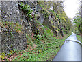
National Cycle Network Route 7 at Bowling
Buttresses holding up the rockface in the cutting at Bowling tunnel.
Image: © Thomas Nugent
Taken: 27 Apr 2015
0.05 miles
8
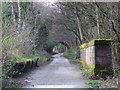
Site of Bowling Upper station
The station was on the Lanarkshire & Dunbartonshire Railway line and closed in 1952. Now part of National Cycle Network Route 7.
See also Image and Image
Image: © Thomas Nugent
Taken: 2 Mar 2008
0.05 miles
9
The railway Inn
At Bowling station. Also close to the harbour, which perhaps explains the anchor on the signs.
Image: © Thomas Nugent
Taken: 2 Mar 2008
0.05 miles
10
National Cycle Network Route 7
Western portal of the short tunnel on the former Lanarkshire & Dunbartonshire Railway line through Bowling. The path leads from the SECC at Glasgow to Loch Lomond.
See also Image
Image: © Thomas Nugent
Taken: 2 Mar 2008
0.05 miles