IMAGES TAKEN NEAR TO
Crown Street, GLASGOW, G5 9XD
Introduction
This page details the photographs taken nearby to Crown Street, G5 9XD by members of the Geograph project.
The Geograph project started in 2005 with the aim of publishing, organising and preserving representative images for every square kilometre of Great Britain, Ireland and the Isle of Man.

There are currently over 7.5m images from over14,400 individuals and you can help contribute to the project by visiting https://www.geograph.org.uk
Image Map (Loading...)


Getting Data...Please wait
Leaflet Map data © OpenStreetMap
Images are licensed for reuse under creativecommons.org/licenses/by-sa/2.0
Notes
- Clicking on the map will re-center to the selected point.
- The higher the marker number, the further away the image location is from the centre of the postcode.
Image Listing (373 Images Found)
Images are licensed for reuse under creativecommons.org/licenses/by-sa/2.0
Image
Details
Distance
1
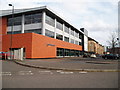
Gorbals Library
The local Glasgow Housing Association office is housed in the upper floors. 9th April 2010 4.35pm.
Image: © Gordon Dowie
Taken: 9 Apr 2010
0.03 miles
2

Gorbals Parish Church
At the corner of Laurieston Road (on left) and Hospital Street.
Image: © Thomas Nugent
Taken: 8 May 2016
0.05 miles
3

Gorbals Parish Church
At the corner of Laurieston Road (on left) and Hospital Street.
Image: © Thomas Nugent
Taken: 8 May 2016
0.05 miles
4

Laurieston Road
At Cleland Street, which is on the left.
Image: © Thomas Nugent
Taken: 8 May 2016
0.06 miles
5

St Luke's Business Estate
Network Rail owned business park at St Luke's Place. The City Union Railway line runs behind the buildings.
See also Image
Image: © Thomas Nugent
Taken: 8 May 2016
0.08 miles
6

Cleland Street railway bridge
Carries the City Union Railway line.
Image: © Thomas Nugent
Taken: 8 May 2016
0.08 miles
7
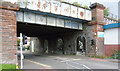
Cleland Street railway bridge
The City Union line crosses the street here.
Image: © Thomas Nugent
Taken: 20 Aug 2023
0.08 miles
8
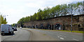
Laurieston Road Railway arches
This section of arches is alongside Laurieston road, between Cleland Street and Cumberland Street. The City Union line curves away to the west, behind the trees. A disused line continues south towards Pollokshields.
Image: © Thomas Nugent
Taken: 8 May 2016
0.08 miles
9

Laurieston Road Railway arches
This section of arches is alongside Laurieston road, between Cleland Street and Cumberland Street. The City Union line curves away to the west, behind the trees. A disused line continues south towards Pollokshields.
Image: © Thomas Nugent
Taken: 8 May 2016
0.08 miles
10

Laurieston Road
The City Union Railway line can be seen on the left, the towerblock is at the City of Glasgow College Riverside Campus.
Image: © Thomas Nugent
Taken: 8 May 2016
0.08 miles