IMAGES TAKEN NEAR TO
Cumberland Street, GLASGOW, G5 9QA
Introduction
This page details the photographs taken nearby to Cumberland Street, G5 9QA by members of the Geograph project.
The Geograph project started in 2005 with the aim of publishing, organising and preserving representative images for every square kilometre of Great Britain, Ireland and the Isle of Man.

There are currently over 7.5m images from over14,400 individuals and you can help contribute to the project by visiting https://www.geograph.org.uk
Image Map
Images are licensed for reuse under creativecommons.org/licenses/by-sa/2.0
Notes
- Clicking on the map will re-center to the selected point.
- The higher the marker number, the further away the image location is from the centre of the postcode.
Image Listing (315 Images Found)
Images are licensed for reuse under creativecommons.org/licenses/by-sa/2.0
Image
Details
Distance
1

Site of two former railway stations
Gorbals Junction (no longer a junction) stood where the two viaducts meet in a V shape (as seen in the tree line). Main Street station on the City Union line was on the left, Gorbals station on the Glasgow, Barrhead and Neilston Direct Railway line was on the right (the steps up to the site of the station can be seen behind the grey fence).
Image: © Thomas Nugent
Taken: 8 May 2016
0.00 miles
2

Site of two former railway stations
Gorbals Junction (no longer a junction) stood where the two viaducts meet in a V shape (as seen in the tree line). Main Street station on the City Union line was on the left, Gorbals station on the Glasgow, Barrhead and Neilston Direct Railway line was on the right (the steps up to the site of the station can be seen behind the grey fence).
Image: © Thomas Nugent
Taken: 8 May 2016
0.00 miles
3
Site of two former railway stations
Gorbals Junction (no longer a junction) stood where the two viaducts meet in a V shape (as seen in the tree line). Main Street station on the City Union line was on the left, Gorbals station on the Glasgow, Barrhead and Neilston Direct Railway line was on the right (the steps up to the site of the station can be seen behind the grey fence).
Image: © Thomas Nugent
Taken: 8 May 2016
0.00 miles
4
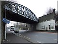
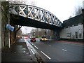
Railway bridge in The Gorbals
Carries the former City Union Railway line over Gorbals Street. Note the evidence of a parallel bridge, now removed. This is the site of former Main Street station.
Image: © Thomas Nugent
Taken: 13 Feb 2009
0.01 miles
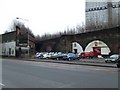
5
Gorbals railway station (site), Glasgow
Opened in 1877 by the Glasgow Barrhead & Kilmarnock Joint Railway, later part of both the Caledonian and Glasgow & South Western Railways, when the line from Kilmarnock to Southside station was extended northwards to a new terminus at Glasgow St. Enoch. Gorbals was the only intermediate station and was close to the old station at Southside. It was also adjacent to Main Street Station.
View south west from Lauriston Road. The platforms had been on the viaduct here, but it no longer carried a railway line when this image was taken.
Image: © Nigel Thompson
Taken: 29 Apr 2019
0.02 miles
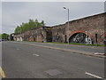
6
Gorbals railway arches
Under a disused line beside Gorbals Street, now home to a car repair workshop. The red brick structure on the left is the site of the former Main Street station. The steps on the right led to the former Gorbals station.
Image: © Thomas Nugent
Taken: 13 Feb 2009
0.02 miles
7
Gorbals Street
Looking towards the City Centre. The City Chambers can just be seen off in the distance.
Image: © Stephen Sweeney
Taken: 17 Dec 2008
0.02 miles
8
The A730 Gorbals Street
A confusing mish-mash of signs, lights, bollards and islands at the junction with Cumberland Street at the Brazen Head pub.
Image: © Thomas Nugent
Taken: 20 Aug 2023
0.02 miles
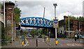
9

Gorbals Street railway bridge renovation
The City Union Railway bridge at the site of the long closed Main Street station which was immediately to the right of the bridge. Shot blasting is going on inside the sealed section of the bridge.
Image: © Thomas Nugent
Taken: 8 May 2016
0.02 miles
10

Gorbals Street railway bridge renovation
The City Union Railway bridge at the site of the long closed Main Street station which was immediately to the right of the bridge. Shot blasting is going on inside the sealed section of the bridge.
The tower in the distance is at the City Chambers, with the large "People Make Glasgow" banner on the City of Glasgow College building at Cathedral Street also visible.
Image: © Thomas Nugent
Taken: 8 May 2016
0.02 miles