IMAGES TAKEN NEAR TO
Cavendish Place, GLASGOW, G5 9NS
Introduction
This page details the photographs taken nearby to Cavendish Place, G5 9NS by members of the Geograph project.
The Geograph project started in 2005 with the aim of publishing, organising and preserving representative images for every square kilometre of Great Britain, Ireland and the Isle of Man.

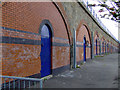
There are currently over 7.5m images from over14,400 individuals and you can help contribute to the project by visiting https://www.geograph.org.uk
Image Map
Images are licensed for reuse under creativecommons.org/licenses/by-sa/2.0
Notes
- Clicking on the map will re-center to the selected point.
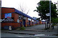
- The higher the marker number, the further away the image location is from the centre of the postcode.
Image Listing (267 Images Found)
Images are licensed for reuse under creativecommons.org/licenses/by-sa/2.0
Image
Details
Distance
1
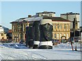
M74 Northern Extension construction
The former Abbotsford Primary School will soon disappear from view from Eglinton Street.
The 1984 Tour de France "King of the Mountains" winner Robert Millar attended Abbotsford for four years in the early 1960s. http://en.wikipedia.org/wiki/Robert_Millar http://www.cyclingarchives.com/coureurfiche.php?coureurid=6053
Image: © Thomas Nugent
Taken: 6 Jan 2010
0.03 miles
2
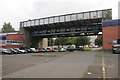
Railway bridge
This bridge appears to be much wider than it needs to be. It, together with a similar bridge over Salisbury Street just to the east [http://www.geograph.org.uk/photo/1168706], were part of Cumberland Street Station, built in 1900 (originally called Eglinton Street) by the Glasgow and South Western Railway. Presumably the wider section here was to accommodate the platforms.
Image: © Richard Sutcliffe
Taken: 30 Aug 2017
0.05 miles
3
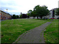
Wellcroft Place
The City Union railway line can be seen on the left. Eglinton Street is behind the photographer. The 1984 Tour de France King of the Mountains winner, Robert Millar Image, spent his early childhood living here in the early 1960s until The Gorbals tenements were demolished.
Image: © Thomas Nugent
Taken: 31 Jul 2011
0.05 miles
4
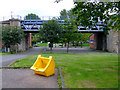
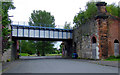
Gorbals railway bridge
Carries the City Union line. Viewed from Cavendish Place, Cumberland Street is through the arch.
Image: © Thomas Nugent
Taken: 31 Jul 2011
0.05 miles
5
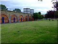
Gorbals railway arches
This elevated line connects runs from the north side of the Clyde to Shields Junction. Viewed from Wellcroft Place.
Image: © Thomas Nugent
Taken: 31 Jul 2011
0.06 miles
6
Salisbury Street
Passes under the City Union railway line between Cavendish Place and Cumberland Street at the site of the former Cumberland Street station.
Image: © Thomas Nugent
Taken: 31 Jul 2011
0.06 miles
7
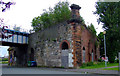
Salisbury Street
The former Cumberland Street railway station. The line is still in use for freight and occasional train movements only.
Image: © Thomas Nugent
Taken: 31 Jul 2011
0.06 miles
8
Arches beneath railway line
Beneath the currently disused St Enoch line.
Image: © Stephen Sweeney
Taken: 28 Jan 2009
0.06 miles
9
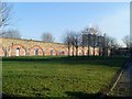
Gorbals railway arches
The line carries the City Union line from the north side of the Clyde to Shields Junction. Wellcroft Place out of sight to the right.
Image: © Thomas Nugent
Taken: 31 Jul 2011
0.07 miles
10
Cumberland Street
Industrial units, backing onto the City Union railway line.
Image: © Thomas Nugent
Taken: 31 Jul 2011
0.07 miles