IMAGES TAKEN NEAR TO
Bridge Street, GLASGOW, G5 9HU
Introduction
This page details the photographs taken nearby to Bridge Street, G5 9HU by members of the Geograph project.
The Geograph project started in 2005 with the aim of publishing, organising and preserving representative images for every square kilometre of Great Britain, Ireland and the Isle of Man.

There are currently over 7.5m images from over14,400 individuals and you can help contribute to the project by visiting https://www.geograph.org.uk
Image Map
Images are licensed for reuse under creativecommons.org/licenses/by-sa/2.0
Notes
- Clicking on the map will re-center to the selected point.
- The higher the marker number, the further away the image location is from the centre of the postcode.
Image Listing (954 Images Found)
Images are licensed for reuse under creativecommons.org/licenses/by-sa/2.0
Image
Details
Distance
1

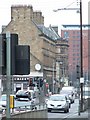
Bridge Street
Looking along the A77 towards the city centre.
Image: © Thomas Nugent
Taken: 8 May 2016
0.01 miles
2
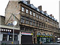
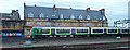
Former Bridge Street station
The Bridge Street frontage of the building. See the trackside view here Image
Image: © Thomas Nugent
Taken: 27 Aug 2008
0.01 miles
3
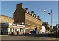
Former Bridge Street Railway Station building and The Laurieston
Bridge Street was the terminus of the railways from the south before the building of Central Station, although this is not the original building. The station entrance occupied the central bays with retail premises either side and offices above. Opened in 1890 and Listed Category B http://portal.historicenvironment.scot/designation/LB33496.
The Laurieston public house on the corner is also Listed, Category C http://portal.historicenvironment.scot/designation/LB51537 as it represents a complete 1960s modernisation of an earlier building which survives near-intact.
Image: © Alan Murray-Rust
Taken: 27 Jun 2019
0.01 miles
4
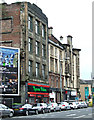
Bridge Street
A trio of Category B Listed buildings.
Nearest the camera is the Art Deco former Scottish Co-operative Wholesale Society drapery warehouse http://data.historic-scotland.gov.uk/pls/htmldb/f?p=2200:15:0::::BUILDING:49930 .
Next is the former South Branch of the Savings Bank of Glasgow http://data.historic-scotland.gov.uk/pls/htmldb/f?p=2200:15:0::::BUILDING:33494 .
On the corner of Norfolk Street is a tenement and pub by James Miller http://data.historic-scotland.gov.uk/pls/htmldb/f?p=2200:15:0::::BUILDING:33520 .
Image: © Thomas Nugent
Taken: 6 Oct 2013
0.01 miles
5
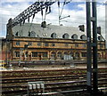
Former Bridge Street station
South of Glasgow Central, on the opposite bank of the Clyde. Opened in 1840, it became the main Caledonian Railway terminus in the city until its closure in 1905 when Glasgow Central was extended. See the street side of the building here Image
Image: © Thomas Nugent
Taken: 19 Jul 2008
0.01 miles
6
Bridge Street
The building on the left is the former Bridge Street station, Jurys Inn is on the other side of the Clyde. Viewed from Eglington Street.
Image: © Thomas Nugent
Taken: 13 Feb 2009
0.01 miles
7
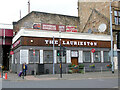
The Laurieston public house
On Bridge Street at Norfolk Street.
Note the fairly new 'old' adverts on the wall behind Image
Image: © Thomas Nugent
Taken: 24 Sep 2023
0.02 miles
8
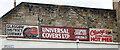
Old adverts on Bridge Street
Fairly new old-style adverts above the Laurieston Bar Image
Image: © Thomas Nugent
Taken: 24 Sep 2023
0.02 miles
9
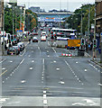
Bridge Street and Eglinton Street
Looking south from Jamaica Bridge. The lack of traffic in the foreground is due to the Great Scottish Run which resulted in several road closures in and around the city centre.
Image: © Thomas Nugent
Taken: 6 Oct 2013
0.02 miles
10
London Midland Class 320 at Glasgow Central
One of the modified Class 321 trains from London Midland which were brought in to boost Scotrail capacity during the temporary closure of Glasgow Queen Street. The London Midland livery was retained.
Image: © Thomas Nugent
Taken: 13 Apr 2016
0.02 miles