IMAGES TAKEN NEAR TO
Cumberland Street, GLASGOW, G5 9AD
Introduction
This page details the photographs taken nearby to Cumberland Street, G5 9AD by members of the Geograph project.
The Geograph project started in 2005 with the aim of publishing, organising and preserving representative images for every square kilometre of Great Britain, Ireland and the Isle of Man.

There are currently over 7.5m images from over14,400 individuals and you can help contribute to the project by visiting https://www.geograph.org.uk
Image Map
Images are licensed for reuse under creativecommons.org/licenses/by-sa/2.0
Notes
- Clicking on the map will re-center to the selected point.
- The higher the marker number, the further away the image location is from the centre of the postcode.
Image Listing (304 Images Found)
Images are licensed for reuse under creativecommons.org/licenses/by-sa/2.0
Image
Details
Distance
1
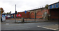
Site of the Kiloran Bar
At the corner of Cumberland Street and Eglinton Street (foreground).
See the scene in January 2010 Image
Image: © Thomas Nugent
Taken: 15 Oct 2016
0.03 miles
2
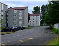
Eglinton Court
Off Eglinton Street, in the Gorbals.
Image: © Thomas Nugent
Taken: 31 Jul 2011
0.03 miles
3
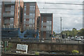
The view from the track
A steady journey into the Central Station at Glasgow gives time to take images along the track.
Image: © Malcolm Neal
Taken: 21 Aug 2018
0.04 miles
4
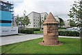
Industrial monument beside Abbotsford Place
A recently cleaned and re-sited six-sided monument, which used to be at the entrance to the Citizens Garden [http://www.geograph.org.uk/photo/4953054]. It has the date '1990' inscribed on the top-most stone. There are three carved sections, depicting industrial processes.
Image: © Richard Sutcliffe
Taken: 30 Aug 2017
0.04 miles
5
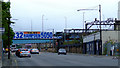
Eglington Street
Looking south towards the former City Union Railway line bridge.
Image: © Thomas Nugent
Taken: 13 Feb 2009
0.04 miles
6
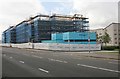
Under construction
A new development - Laurieston Phase 1C - which will provide 55 new flats for the New Gorbals Housing Association.
Image: © Richard Sutcliffe
Taken: 30 Aug 2017
0.04 miles
7
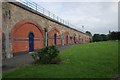
Railway arches, Gorbals
The grassy area is the site of the western end of the former Cumberland Road station building built in 1900 (originally called Eglinton Street) by the Glasgow and South Western Railway. The end of the building on Eglinton Street had a bar called 'The Office' [https://canmore.org.uk/site/213009/glasgow-cumberland-street-station].
I'll be late home this evening, dear - I'm working late at the office...'
Image: © Richard Sutcliffe
Taken: 30 Aug 2017
0.04 miles
8
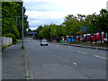
Cumberland Street
A once thriving part of The Gorbals is now home to a few industrial units and brownfiled sites where the original tenements and then the towerblocks once stood.
Image: © Thomas Nugent
Taken: 31 Jul 2011
0.04 miles
9
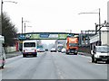
Eglinton Street
The railway bridge carries the City Union freight only line from the north side of the Clyde to Shields Junction.
Image: © Thomas Nugent
Taken: 31 Jul 2011
0.04 miles
10
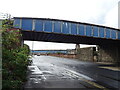
Railway bridge over Eglinton Street (A77), Glasgow
Image: © JThomas
Taken: 14 Sep 2021
0.05 miles