IMAGES TAKEN NEAR TO
Salkeld Street, GLASGOW, G5 8HE
Introduction
This page details the photographs taken nearby to Salkeld Street, G5 8HE by members of the Geograph project.
The Geograph project started in 2005 with the aim of publishing, organising and preserving representative images for every square kilometre of Great Britain, Ireland and the Isle of Man.

There are currently over 7.5m images from over14,400 individuals and you can help contribute to the project by visiting https://www.geograph.org.uk
Image Map (Loading...)


Getting Data...Please wait
Leaflet Map data © OpenStreetMap
Images are licensed for reuse under creativecommons.org/licenses/by-sa/2.0
Notes
- Clicking on the map will re-center to the selected point.
- The higher the marker number, the further away the image location is from the centre of the postcode.
Image Listing (249 Images Found)
Images are licensed for reuse under creativecommons.org/licenses/by-sa/2.0
Image
Details
Distance
1
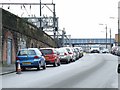
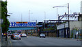
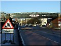
Salkeld Street
The main line south from Glasgow Central is on the left, the bridge in the distance carries the former City Union Railway line.
Image: © Thomas Nugent
Taken: 13 Feb 2009
0.02 miles
2
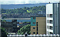
Glasgow rooftops
The northern section of the M74 motorway is prominent in this view from The Lighthouse. Queens park flag pole can be seen amongst the trees in the right distance.
Image: © Thomas Nugent
Taken: 12 Aug 2013
0.02 miles
3
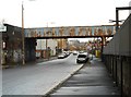
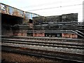
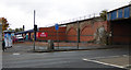
Railway bridge over Salkeld Street
Four railway lines used to cross here (there are now just two), but following the closure of Cumberland Street station to the east in 1966, the southern two lines were removed and the bridge which carried them was demolished. The remains of the bridge supports can be seen on the left.
Image: © Richard Sutcliffe
Taken: 17 Dec 2019
0.02 miles
4
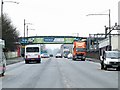
Eglinton Street
The railway bridge carries the City Union freight only line from the north side of the Clyde to Shields Junction.
Image: © Thomas Nugent
Taken: 31 Jul 2011
0.03 miles
5
Eglington Street
Looking south towards the former City Union Railway line bridge.
Image: © Thomas Nugent
Taken: 13 Feb 2009
0.03 miles
6
Eglinton Street
At the junction with Cumberland Street, on the edge of The Gorbals.
Image: © Thomas Nugent
Taken: 6 Jan 2010
0.03 miles
7
Old bridge support
Four railway lines used to cross the main line here (there are now just two), but following the closure of Cumberland Street station to the east in 1966, the southern two lines were removed and the bridge which carried them was demolished. The remains of one of the bridge supports can be seen here.
Image: © Richard Sutcliffe
Taken: 17 Dec 2019
0.03 miles
8
Eglinton Street railway bridge
Looking north towards the city centre
Image: © Thomas Nugent
Taken: 6 Jan 2010
0.04 miles
9
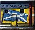
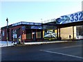
Site of the Kiloran Bar
At the corner of Cumberland Street and Eglinton Street (foreground).
See the scene in January 2010 Image
Image: © Thomas Nugent
Taken: 15 Oct 2016
0.04 miles