IMAGES TAKEN NEAR TO
Riverview Gardens, GLASGOW, G5 8EG
Introduction
This page details the photographs taken nearby to Riverview Gardens, G5 8EG by members of the Geograph project.
The Geograph project started in 2005 with the aim of publishing, organising and preserving representative images for every square kilometre of Great Britain, Ireland and the Isle of Man.

There are currently over 7.5m images from over14,400 individuals and you can help contribute to the project by visiting https://www.geograph.org.uk
Image Map
Images are licensed for reuse under creativecommons.org/licenses/by-sa/2.0
Notes
- Clicking on the map will re-center to the selected point.
- The higher the marker number, the further away the image location is from the centre of the postcode.
Image Listing (573 Images Found)
Images are licensed for reuse under creativecommons.org/licenses/by-sa/2.0
Image
Details
Distance
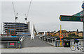
1
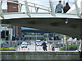
West Street bridges
The Tradeston Bridge is in the foreground, with a light blue sliver of the M74 northern extension bridge immediately below its deck. The black and yellow hatchings are on the Glasgow to Paisley railway line where it crosses Bridge Street at the subway station and the bridge immediately beyond that carries the City Union railway line over West Street.
Image: © Thomas Nugent
Taken: 24 Aug 2014
0.05 miles
2
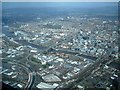
Tradeston
Bounded by the river,the M8, the M74 extension and the railway lines leading in/out of Central Station.
Image: © Jim Smillie
Taken: 7 Apr 2011
0.05 miles
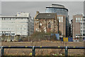
3
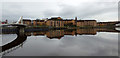
Riverview Gardens
On the south bank of the Clyde opposite The Broomielaw.
Image: © Thomas Nugent
Taken: 10 Nov 2018
0.06 miles
4
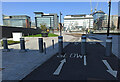
Cycle path on West Street
At the north end of West Street, at the new Barclays Bank campus.
Image: © Thomas Nugent
Taken: 22 Apr 2022
0.06 miles
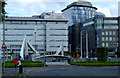
5

New buildings beside the Clyde
Recently built beside the River Clyde. The buildings on the right are the new headquarters of Barclays Bank in Glasgow.
Image: © Richard Sutcliffe
Taken: 28 Apr 2022
0.06 miles
6

Barclays Bank
The new Glasgow headquarters of Barclays Bank, built beside the River Clyde in Tradeston. The Category B listed http://portal.historicenvironment.scot/designation/LB33501 former Kingston House, dating from 1878 has been incorporated into the new complex.
Image: © Richard Sutcliffe
Taken: 28 Apr 2022
0.06 miles
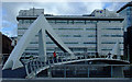
7
Barclays Bank development at Tradeston
By the Tradeston Bridge, which is also known as the squiggly bridge.
Image: © Thomas Nugent
Taken: 6 Nov 2019
0.07 miles
9
The Broomielaw
With the squiggly bridge in the centre. Viewed from West Street.
Image: © Thomas Nugent
Taken: 18 Jul 2011
0.07 miles
10
The squiggly bridge
With the BT building on The Broomielaw in the background. Formally known as the Tradeston Bridge.
Image: © Thomas Nugent
Taken: 18 Jul 2011
0.07 miles