IMAGES TAKEN NEAR TO
Parkholm Quadrant, GLASGOW, G53 7ZH
Introduction
This page details the photographs taken nearby to Parkholm Quadrant, G53 7ZH by members of the Geograph project.
The Geograph project started in 2005 with the aim of publishing, organising and preserving representative images for every square kilometre of Great Britain, Ireland and the Isle of Man.

There are currently over 7.5m images from over14,400 individuals and you can help contribute to the project by visiting https://www.geograph.org.uk
Image Map
Images are licensed for reuse under creativecommons.org/licenses/by-sa/2.0
Notes
- Clicking on the map will re-center to the selected point.
- The higher the marker number, the further away the image location is from the centre of the postcode.
Image Listing (12 Images Found)
Images are licensed for reuse under creativecommons.org/licenses/by-sa/2.0
Image
Details
Distance
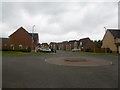
1
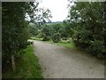
Path off Parkmanor Avenue
An informal recreational area surrounding a large area of recently built houses.
Image: © Richard Webb
Taken: 28 Aug 2016
0.08 miles
2
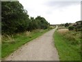
Park off Parkmanor Avenue
The new houses in South Nitshill have been surrounded by informal recreational land and paths.
Image: © Richard Webb
Taken: 28 Aug 2016
0.08 miles
3
Path beside Parkmanor Avenue
One of a network of paths on the edge of a new housing development in South Nitshill.
Image: © Richard Webb
Taken: 28 Aug 2016
0.10 miles
4
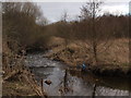
Brock Burn near Darnley Mill
Near Darnley Mill the Brock Burn winds through the trees with many little meanders.
Image: © Alec MacKinnon
Taken: 6 Mar 2016
0.15 miles
5
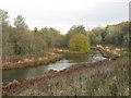
Darnley Mill Country Park
Darnley Mill Country Park is a site of importance for nature conservation in the southwest of the Glasgow. Its mosaic of habitats supports a diverse range of animals and plants. The habitats include grassland, wetland, open water (pond), scrub and a wooded river valley. The diverse species in the park include dippers, sedge warblers, reed buntings, buzzards and orange-tip butterflies.
Image: © G Laird
Taken: 11 Nov 2013
0.18 miles
6
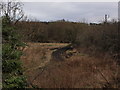
New paths
New paths have been bulldozed in Dams to Darnley Park, at its north end near Darnley Mill.
Image: © Alec MacKinnon
Taken: 6 Mar 2016
0.18 miles
7
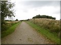
Parkmanor Avenue
South Nitshill moves ever further southwards. Newly built houses well defended by a set of horrid speed bumps along Parkmanor Avenue.
Image: © Richard Webb
Taken: 28 Aug 2016
0.19 miles
8
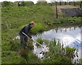
Dams to Darnley Country Park SUDS pond
Sampling for caddisflies as part of an identification training course in Dams to Darnley Country Park.
The pond is a SUDS (sustainable drainage system) pond, situated just beside the Brock Burn, over which a path crosses on the concrete bridge on the right.
Image: © Richard Sutcliffe
Taken: 28 May 2013
0.20 miles
9
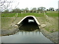
Brock Burn
Brock Burn passing under an embankment. It appears to be a flood prevention scheme.
Image: © Iain Thompson
Taken: 22 Apr 2006
0.20 miles
10
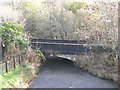
Road Bridge over the Brock Burn
The bridge carries Corselet Road, a minor road, south from Nitshill Road towards Waulkmill Glen Reservoir.
Image: © G Laird
Taken: 11 Nov 2013
0.21 miles