IMAGES TAKEN NEAR TO
Patterton Range Drive, GLASGOW, G53 7YZ
Introduction
This page details the photographs taken nearby to Patterton Range Drive, G53 7YZ by members of the Geograph project.
The Geograph project started in 2005 with the aim of publishing, organising and preserving representative images for every square kilometre of Great Britain, Ireland and the Isle of Man.

There are currently over 7.5m images from over14,400 individuals and you can help contribute to the project by visiting https://www.geograph.org.uk
Image Map
Images are licensed for reuse under creativecommons.org/licenses/by-sa/2.0
Notes
- Clicking on the map will re-center to the selected point.
- The higher the marker number, the further away the image location is from the centre of the postcode.
Image Listing (7 Images Found)
Images are licensed for reuse under creativecommons.org/licenses/by-sa/2.0
Image
Details
Distance
1
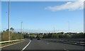
M77 going north before Junction 3
You can see Glasgow in the distance
Image: © Josie Campbell
Taken: 7 Oct 2011
0.06 miles
2
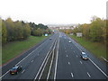
M77 at Patterton
Looking north towards Junction 3 from the former farm bridge at Patterton.
Image: © G Laird
Taken: 11 Nov 2013
0.11 miles
3
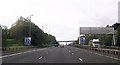
Three lanes become two at Patterton
M77 southbound
Image: © John Firth
Taken: 15 May 2014
0.14 miles
4
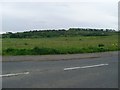
Woodland by the M77
From Leggatston Drive, Southpark.
Image: © Stephen Sweeney
Taken: 25 May 2009
0.15 miles
5
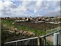
Developing housing
This still-growing housing development makes an interesting comparison with the appearance of this area as seen in the earliest Geograph image, Image
Image: © Alec MacKinnon
Taken: 13 Apr 2022
0.20 miles
6
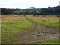
Muddy Track, Darnley
Muddy track on ground between DIY store and M77.
Image: © Iain Thompson
Taken: 17 Mar 2006
0.23 miles
7
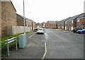
Range Drive
New houses on Range Drive. The sign giving the name of the road is rather unhelpful - it faces the wrong way! See [http://www.geograph.org.uk/photo/5274512] for the view from the other side.
Image: © Richard Sutcliffe
Taken: 6 Feb 2017
0.24 miles