IMAGES TAKEN NEAR TO
Bellflower Gardens, GLASGOW, G53 7XD
Introduction
This page details the photographs taken nearby to Bellflower Gardens, G53 7XD by members of the Geograph project.
The Geograph project started in 2005 with the aim of publishing, organising and preserving representative images for every square kilometre of Great Britain, Ireland and the Isle of Man.

There are currently over 7.5m images from over14,400 individuals and you can help contribute to the project by visiting https://www.geograph.org.uk
Image Map
Images are licensed for reuse under creativecommons.org/licenses/by-sa/2.0
Notes
- Clicking on the map will re-center to the selected point.
- The higher the marker number, the further away the image location is from the centre of the postcode.
Image Listing (33 Images Found)
Images are licensed for reuse under creativecommons.org/licenses/by-sa/2.0
Image
Details
Distance
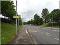
1
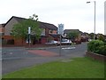
Waulkglen Road
Main road into Southpark Village.
Image: © Stephen Sweeney
Taken: 25 May 2009
0.10 miles
3
Southpark Village
Just south of Darnley, Glasgow.
Image: © Stephen Sweeney
Taken: 25 May 2009
0.11 miles
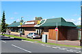
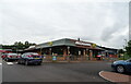
4
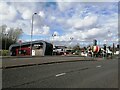
Darnley drive-through Costa coffee shop
Image: © Alec MacKinnon
Taken: 13 Apr 2022
0.15 miles
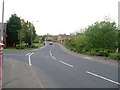
6
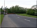
Approaching bend in Waulkglen Road
Next to Darnley Mains Park.
Image: © Stephen Sweeney
Taken: 25 May 2009
0.15 miles
7
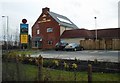
The Old Plane Tree
Public house and restaurant beside the new housing development at Darnley Mains. It opened in December 2015.
Image: © Richard Sutcliffe
Taken: 6 Feb 2017
0.16 miles
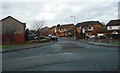
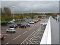
8
Mc Donald's Restaurant on Darnley Mains Road
Image: © JThomas
Taken: 14 Sep 2021
0.17 miles