IMAGES TAKEN NEAR TO
Parkhouse Road, GLASGOW, G53 7ST
Introduction
This page details the photographs taken nearby to Parkhouse Road, G53 7ST by members of the Geograph project.
The Geograph project started in 2005 with the aim of publishing, organising and preserving representative images for every square kilometre of Great Britain, Ireland and the Isle of Man.

There are currently over 7.5m images from over14,400 individuals and you can help contribute to the project by visiting https://www.geograph.org.uk
Image Map
Images are licensed for reuse under creativecommons.org/licenses/by-sa/2.0
Notes
- Clicking on the map will re-center to the selected point.
- The higher the marker number, the further away the image location is from the centre of the postcode.
Image Listing (29 Images Found)
Images are licensed for reuse under creativecommons.org/licenses/by-sa/2.0
Image
Details
Distance
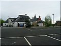
1
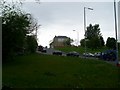
Traffic on Parkhouse Road
Leads to Nitshill and Barrhead.
Image: © Stephen Sweeney
Taken: 25 May 2009
0.02 miles
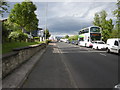
2
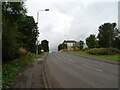
Parkhouse Road (B773)
Heading west towards Barrhead.
Image: © JThomas
Taken: 14 Sep 2021
0.03 miles
4
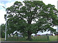
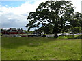
The Darnley Oak
This Oak is sited at a set of traffic lights on the A726 at Nitshill Rd. It is protected by a short fence line.
Image: © HUGH CRAIG
Taken: 19 Jun 2008
0.09 miles
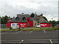
5
Ashoka at the Mill
Indian restaurant in the old Darnley Mill.
Image: © Stephen Sweeney
Taken: 25 May 2009
0.11 miles
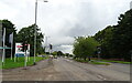
7
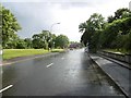
Kennishead Road
Looking towards Nitshill Road.
Image: © Richard Webb
Taken: 25 Jun 2016
0.12 miles
8
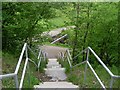
Steps into Darnley Mill Country Park
From Waulkglen Road. Looking to the bridge over the Brock Burn which appears in the First Geograph image in this square.
Image: © Stephen Sweeney
Taken: 25 May 2009
0.14 miles
9
The Darnley Sycamore
This is reputed to be the Sycamore tree under which Mary Queen of Scots and her cousin and second husband, Henry Stewart, Lord Darnley sat while she nursed him back to health from an illness in 1565.
Beyond the tree is Nitshill Road (A726), and the red-coloured building beyond is the former Darnley Mill - now the World Buffet.
Image: © Richard Sutcliffe
Taken: 30 Jun 2015
0.14 miles
10
Kennishead Road
Queuing traffic waiting at the traffic lights at the junction with Nitshill Road (behind the photographer).
On the left is the Shields Land Rover dealership.
Image: © Richard Sutcliffe
Taken: 30 Jun 2015
0.14 miles