IMAGES TAKEN NEAR TO
Langhaul Court, GLASGOW, G53 7RU
Introduction
This page details the photographs taken nearby to Langhaul Court, G53 7RU by members of the Geograph project.
The Geograph project started in 2005 with the aim of publishing, organising and preserving representative images for every square kilometre of Great Britain, Ireland and the Isle of Man.

There are currently over 7.5m images from over14,400 individuals and you can help contribute to the project by visiting https://www.geograph.org.uk
Image Map
Images are licensed for reuse under creativecommons.org/licenses/by-sa/2.0
Notes
- Clicking on the map will re-center to the selected point.
- The higher the marker number, the further away the image location is from the centre of the postcode.
Image Listing (11 Images Found)
Images are licensed for reuse under creativecommons.org/licenses/by-sa/2.0
Image
Details
Distance
1
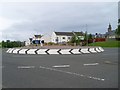
Roundabout near Leverndale Hospital
In a section of the hospital grounds that is being redeveloped into housing.
Image: © Stephen Sweeney
Taken: 25 May 2009
0.15 miles
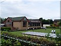
2

Building of Leverndale Hospital
Hidden behind the trees.
Image: © Stephen Sweeney
Taken: 25 May 2009
0.16 miles
3
Crookston Bowling Club
From Crookston Road.
Image: © Stephen Sweeney
Taken: 25 May 2009
0.22 miles
4
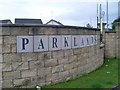
Entrance to Parklands
A new housing estate on the grounds of Leverndale Hospital.
Image: © Stephen Sweeney
Taken: 25 May 2009
0.22 miles

6
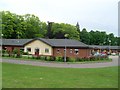
Buildings of Leverndale Hospital
The hospital's main tower can be seen in the background.
Image: © Stephen Sweeney
Taken: 25 May 2009
0.24 miles
7
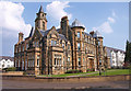
Apartments, Leverndale Hospital
Some of the old hospital have been sympathetically converted and some new buildings added. Making up a residential estate. The water tower behind this fine building.
Image: © wfmillar
Taken: 19 Apr 2011
0.24 miles
8
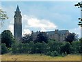
Leverndale Hospital
For details of this hospital (the former Hawkhead Asylum), whose tower is a notable landmark in this area, see the link given at Image
The photo was taken from a cycle route and footpath beside the White Cart Water. The building shown next to the tower was later replaced by modern housing; see Image
Image: © Lairich Rig
Taken: 2 Sep 2005
0.24 miles
9

Tower, Leverndale Hospital
The tower of the former Hawkhead Asylum, later known as Leverndale Hospital, seen from the southwest.
Image: © Richard Sutcliffe
Taken: 14 Feb 2017
0.24 miles
10

Leverndale Hospital tower
The Category A listed tower [http://portal.historicenvironment.scot/designation/LB33597] of the former hospital, seen from the northern side of the White Cart Water.
Image: © Richard Sutcliffe
Taken: 12 Sep 2018
0.24 miles