IMAGES TAKEN NEAR TO
Seamill Path, GLASGOW, G53 7QQ
Introduction
This page details the photographs taken nearby to Seamill Path, G53 7QQ by members of the Geograph project.
The Geograph project started in 2005 with the aim of publishing, organising and preserving representative images for every square kilometre of Great Britain, Ireland and the Isle of Man.

There are currently over 7.5m images from over14,400 individuals and you can help contribute to the project by visiting https://www.geograph.org.uk
Image Map
Images are licensed for reuse under creativecommons.org/licenses/by-sa/2.0
Notes
- Clicking on the map will re-center to the selected point.
- The higher the marker number, the further away the image location is from the centre of the postcode.
Image Listing (70 Images Found)
Images are licensed for reuse under creativecommons.org/licenses/by-sa/2.0
Image
Details
Distance
1
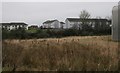
Properties on Panmore Street, Nitshill
Seen from the footpath to the west of Glasgow Museums Resource Centre.
Image: © Richard Sutcliffe
Taken: 20 Jan 2017
0.04 miles
2
Flats on Pinmore Street
Seen from the path beside Glasgow Museums Resource Centre.
Image: © Richard Sutcliffe
Taken: 26 Jan 2018
0.04 miles
3
Flats on Panmore Street, Nitshill
Seen from the footpath to the west of Glasgow Museums Resource Centre.
Image: © Richard Sutcliffe
Taken: 20 Jan 2017
0.05 miles
4
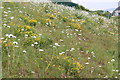
Wild flowers at Glasgow Museums Resource Centre
Ox-eye daisies, Leucanthemum vulgare; and Bird's foot Trefoil, Lotus corniculatus at the back of GMRC, on the railway embankment. The edge of the Council's storage building for road salt on Woodhead Road can just be seen in the distance.
Image: © Richard Sutcliffe
Taken: 16 Jun 2006
0.10 miles
5
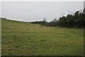
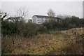
Field to west of Glasgow Museums Resource Centre
Image: © Richard Sutcliffe
Taken: 20 Jan 2017
0.12 miles
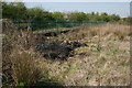
6
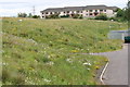
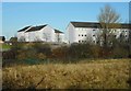
Glasgow Museums Resource Centre
Earth bank beside GMRC in June 2006, before the construction of Phase 2 of the building in 2007. This bank was a good habitat for wildlife until the building was extended. The houses in the background are on Pinmore Street, on the other side of the Glasgow to Barrhead railway line.
Image: © Richard Sutcliffe
Taken: 16 Jun 2006
0.12 miles
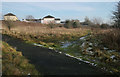
7
Path beside the railway
The railway line to Barrhead is just the other side of the fence.
Image: © Richard Sutcliffe
Taken: 11 May 2016
0.13 miles
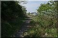
8
Junction of paths
The metalled path leads north and comes out on Pinmore Street near Nitshill Road. The path to the right leads to the other end of Pinmore Street.
Image: © Richard Sutcliffe
Taken: 24 Jan 2019
0.13 miles
9
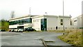
Glasgow Museums Resource Centre
This museum in South Nitshill opened in late 2003, and provided storage for approximately two hundred thousand objects from Glasgow's museum collections. It is divided internally into several "pods", in which the temperature and humidity are carefully controlled. Only the front section of the building is visible here, with a larger portion extending behind it.
Following a major refurbishment, the centre reopened to the public in September 2009; it will now store over a million items.
Set some distance from the main road, the GMRC is not in the most prominent of locations, and remains rather less well-known than some of Glasgow's other museums, but I consider it to be well worth a visit. There are daily tours; I took part in one on the day this photo was taken.
For later pictures by other contributors, see, for example, Image / Image / Image / Image
Image: © Lairich Rig
Taken: 9 Dec 2005
0.13 miles
10
Glasgow Museums Resource Centre
Fence at side of GMRC. The path on the other side leads up towards the railway line and then on to Salterland Road.
The vegetation beside the fence had been burnt during a warm dry spell in April 2015.
Image: © Richard Sutcliffe
Taken: 22 Apr 2015
0.14 miles