IMAGES TAKEN NEAR TO
Pinmore Street, GLASGOW, G53 7PY
Introduction
This page details the photographs taken nearby to Pinmore Street, G53 7PY by members of the Geograph project.
The Geograph project started in 2005 with the aim of publishing, organising and preserving representative images for every square kilometre of Great Britain, Ireland and the Isle of Man.

There are currently over 7.5m images from over14,400 individuals and you can help contribute to the project by visiting https://www.geograph.org.uk
Image Map
Images are licensed for reuse under creativecommons.org/licenses/by-sa/2.0
Notes
- Clicking on the map will re-center to the selected point.
- The higher the marker number, the further away the image location is from the centre of the postcode.
Image Listing (29 Images Found)
Images are licensed for reuse under creativecommons.org/licenses/by-sa/2.0
Image
Details
Distance
1
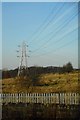
Electricity pylon
The wall and fence in the foreground are between a footpath and the railway.
Image: © Richard Sutcliffe
Taken: 26 Jan 2018
0.11 miles
2
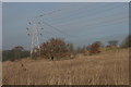
Birds on the lines
Nearly a hundred crows perching on power lines, Nitshill.
Image: © Richard Sutcliffe
Taken: 24 Jan 2019
0.11 miles
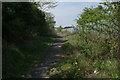
3
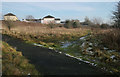
Junction of paths
The metalled path leads north and comes out on Pinmore Street near Nitshill Road. The path to the right leads to the other end of Pinmore Street.
Image: © Richard Sutcliffe
Taken: 24 Jan 2019
0.13 miles
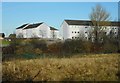
4
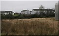
Properties on Panmore Street, Nitshill
Seen from the footpath to the west of Glasgow Museums Resource Centre.
Image: © Richard Sutcliffe
Taken: 20 Jan 2017
0.13 miles
5
Flats on Pinmore Street
Seen from the path beside Glasgow Museums Resource Centre.
Image: © Richard Sutcliffe
Taken: 26 Jan 2018
0.14 miles
6
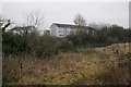
Flats on Panmore Street, Nitshill
Seen from the footpath to the west of Glasgow Museums Resource Centre.
Image: © Richard Sutcliffe
Taken: 20 Jan 2017
0.15 miles
7
Path beside the railway
The railway line to Barrhead is just the other side of the fence.
Image: © Richard Sutcliffe
Taken: 11 May 2016
0.16 miles
8
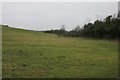
Field to west of Glasgow Museums Resource Centre
Image: © Richard Sutcliffe
Taken: 20 Jan 2017
0.17 miles
9
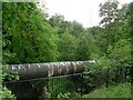
Pipeline over Levern Water
By Nitshill Road.
Image: © Stephen Sweeney
Taken: 25 May 2009
0.18 miles
10
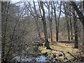
Woodland by the Levern Water
This urban fringe bit of Renfrewshire was once a chemical works fed by a nearby alum quarry according to mid 19th century mapping. Half a century on, it was turning to woodland. View from Levern Bridge on Nitshill Road.
Image: © Richard Webb
Taken: 9 Apr 2013
0.18 miles