IMAGES TAKEN NEAR TO
Ben Lui Place, GLASGOW, G53 7PN
Introduction
This page details the photographs taken nearby to Ben Lui Place, G53 7PN by members of the Geograph project.
The Geograph project started in 2005 with the aim of publishing, organising and preserving representative images for every square kilometre of Great Britain, Ireland and the Isle of Man.

There are currently over 7.5m images from over14,400 individuals and you can help contribute to the project by visiting https://www.geograph.org.uk
Image Map
Images are licensed for reuse under creativecommons.org/licenses/by-sa/2.0
Notes
- Clicking on the map will re-center to the selected point.
- The higher the marker number, the further away the image location is from the centre of the postcode.
Image Listing (23 Images Found)
Images are licensed for reuse under creativecommons.org/licenses/by-sa/2.0
Image
Details
Distance
1
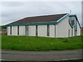
Darnley church
On Glen Moriston Road.
Image: © Stephen Sweeney
Taken: 25 May 2009
0.08 miles
3
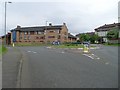
Roundabout in Darnley
On Glen Moriston Road.
Image: © Stephen Sweeney
Taken: 25 May 2009
0.10 miles
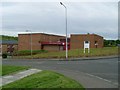
4
Darnley Primary School
From Glen Moriston Road.
Image: © Stephen Sweeney
Taken: 25 May 2009
0.10 miles
5
Ben Vorlich Drive
In the east of Darnley, just off Glen Moriston Road.
Image: © Stephen Sweeney
Taken: 25 May 2009
0.12 miles
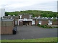
6
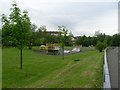
Darnley playpark
By Kennishead Road.
Image: © Stephen Sweeney
Taken: 25 May 2009
0.14 miles
8
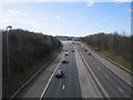
M77
Looking in the direction of Ayrshire along the motorway.
Image: © Richard Webb
Taken: 9 Apr 2013
0.16 miles
9
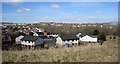
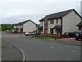
Ben Vorlich Drive
So which Ben Vorlich was it named after? New houses near the M77 seen from the top of a berm which should cut their noise down a bit.
Image: © Richard Webb
Taken: 9 Apr 2013
0.16 miles
10
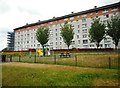
Flats on Glen Clunie Place
Seen from Greenacres Drive.
Image: © Richard Sutcliffe
Taken: 16 Jul 2018
0.17 miles