IMAGES TAKEN NEAR TO
Raeswood Gate, GLASGOW, G53 7HF
Introduction
This page details the photographs taken nearby to Raeswood Gate, G53 7HF by members of the Geograph project.
The Geograph project started in 2005 with the aim of publishing, organising and preserving representative images for every square kilometre of Great Britain, Ireland and the Isle of Man.

There are currently over 7.5m images from over14,400 individuals and you can help contribute to the project by visiting https://www.geograph.org.uk
Image Map
Images are licensed for reuse under creativecommons.org/licenses/by-sa/2.0
Notes
- Clicking on the map will re-center to the selected point.
- The higher the marker number, the further away the image location is from the centre of the postcode.
Image Listing (6 Images Found)
Images are licensed for reuse under creativecommons.org/licenses/by-sa/2.0
Image
Details
Distance
1
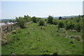
Scrub, Hurlet Hill
The roofs of some of the new houses being built at Roughmussel [http://www.geograph.org.uk/photo/4947046] can be seen on the left.
Image: © Richard Sutcliffe
Taken: 12 May 2016
0.13 miles
2
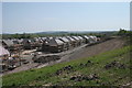
New houses, Roughmussel
New houses under construction, seen from Hurlet Hill.
Image: © Richard Sutcliffe
Taken: 12 May 2016
0.15 miles
3
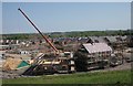
New houses, Roughmussel
New houses under construction, seen from Hurlet Hill.
Image: © Richard Sutcliffe
Taken: 12 May 2016
0.15 miles
4

Hurlet Hill
The scrub on the slope on the right has increased in the last few years since conservation grazing by Highland cattle stopped.
Image: © Richard Sutcliffe
Taken: 12 May 2016
0.17 miles
5
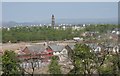
New houses, Roughmussel
New houses under construction, seen from Hurlet Hill. In the background is Bull Wood and the tower of the former Hawkhead Asylum, later Leverndale Hospital.
Image: © Richard Sutcliffe
Taken: 12 May 2016
0.20 miles
6

Dalmellington Road
From Crookston Road.
Image: © Stephen Sweeney
Taken: 25 May 2009
0.24 miles