IMAGES TAKEN NEAR TO
Glen Alby Place, GLASGOW, G53 7GY
Introduction
This page details the photographs taken nearby to Glen Alby Place, G53 7GY by members of the Geograph project.
The Geograph project started in 2005 with the aim of publishing, organising and preserving representative images for every square kilometre of Great Britain, Ireland and the Isle of Man.

There are currently over 7.5m images from over14,400 individuals and you can help contribute to the project by visiting https://www.geograph.org.uk
Image Map
Images are licensed for reuse under creativecommons.org/licenses/by-sa/2.0
Notes
- Clicking on the map will re-center to the selected point.
- The higher the marker number, the further away the image location is from the centre of the postcode.
Image Listing (26 Images Found)
Images are licensed for reuse under creativecommons.org/licenses/by-sa/2.0
Image
Details
Distance
1
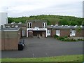
Darnley Primary School
From Glen Moriston Road.
Image: © Stephen Sweeney
Taken: 25 May 2009
0.08 miles
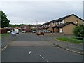
2
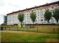
Flats on Glen Clunie Place
Seen from Greenacres Drive.
Image: © Richard Sutcliffe
Taken: 16 Jul 2018
0.09 miles
6
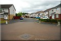
Glen Kyle Drive
Seen from Greenacres Drive.
Image: © Richard Sutcliffe
Taken: 16 Jul 2018
0.12 miles
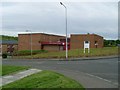
8
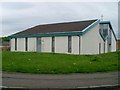
Darnley church
On Glen Moriston Road.
Image: © Stephen Sweeney
Taken: 25 May 2009
0.14 miles
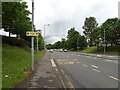
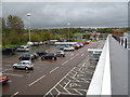
10
Nitshill Road
From the crossing with Glen Moriston Road, at the Darnley Mains retail park.
Image: © Stephen Sweeney
Taken: 25 May 2009
0.16 miles