IMAGES TAKEN NEAR TO
Glen Dene Way, GLASGOW, G53 7GS
Introduction
This page details the photographs taken nearby to Glen Dene Way, G53 7GS by members of the Geograph project.
The Geograph project started in 2005 with the aim of publishing, organising and preserving representative images for every square kilometre of Great Britain, Ireland and the Isle of Man.

There are currently over 7.5m images from over14,400 individuals and you can help contribute to the project by visiting https://www.geograph.org.uk
Image Map
Images are licensed for reuse under creativecommons.org/licenses/by-sa/2.0
Notes
- Clicking on the map will re-center to the selected point.
- The higher the marker number, the further away the image location is from the centre of the postcode.
Image Listing (20 Images Found)
Images are licensed for reuse under creativecommons.org/licenses/by-sa/2.0
Image
Details
Distance
1
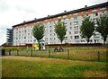
Flats on Glen Clunie Place
Seen from Greenacres Drive.
Image: © Richard Sutcliffe
Taken: 16 Jul 2018
0.08 miles
2
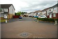
Glen Kyle Drive
Seen from Greenacres Drive.
Image: © Richard Sutcliffe
Taken: 16 Jul 2018
0.09 miles
3
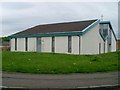
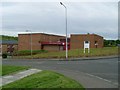
Darnley church
On Glen Moriston Road.
Image: © Stephen Sweeney
Taken: 25 May 2009
0.12 miles
4
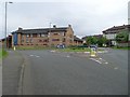
Roundabout in Darnley
On Glen Moriston Road.
Image: © Stephen Sweeney
Taken: 25 May 2009
0.13 miles
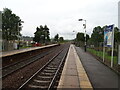
7
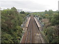
Priesthill & Darnley railway station, Glasgow
Opened in 1990 by British Rail on the line from Glasgow Central to Kilmarnock. View east towards Kennishead and Glasgow.
Image: © Nigel Thompson
Taken: 12 Oct 2013
0.15 miles
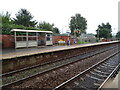
8
Priesthill & Darnley Railway Station
Line towards Nitshill.
Image: © JThomas
Taken: 14 Sep 2021
0.15 miles
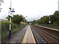
9
Priesthill & Darnley Railway Station
Line east towards Kennishead and Glasgow.
Image: © JThomas
Taken: 14 Sep 2021
0.16 miles
10
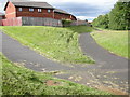
Footpaths behind Glen Esk Drive
Junction of paths leading from Nitshill Road (A726). The one on the left joins Glen Esk Drive. The one on the right runs behind between the houses and the Brock Burn (just out of shot to the right of the trees).
Image: © Richard Sutcliffe
Taken: 30 Jun 2015
0.18 miles