IMAGES TAKEN NEAR TO
Marlach Place, GLASGOW, G53 7FX
Introduction
This page details the photographs taken nearby to Marlach Place, G53 7FX by members of the Geograph project.
The Geograph project started in 2005 with the aim of publishing, organising and preserving representative images for every square kilometre of Great Britain, Ireland and the Isle of Man.

There are currently over 7.5m images from over14,400 individuals and you can help contribute to the project by visiting https://www.geograph.org.uk
Image Map
Images are licensed for reuse under creativecommons.org/licenses/by-sa/2.0
Notes
- Clicking on the map will re-center to the selected point.
- The higher the marker number, the further away the image location is from the centre of the postcode.
Image Listing (5 Images Found)
Images are licensed for reuse under creativecommons.org/licenses/by-sa/2.0
Image
Details
Distance
1

Crookston Lidl
Just off of Crookston Road.
Image: © Stephen Sweeney
Taken: 25 May 2009
0.16 miles
2
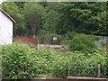
Birdhouse
In a garden on Crookston Road. Looked like a miniature version of the real house it was behind!
Image: © Stephen Sweeney
Taken: 25 May 2009
0.19 miles
3
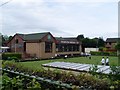
Crookston Bowling Club
From Crookston Road.
Image: © Stephen Sweeney
Taken: 25 May 2009
0.19 miles
4
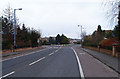
Road into Haughhill estate
Leading off the A736 Crookston Road.
Image: © wfmillar
Taken: 14 Mar 2012
0.21 miles
5

Dalmellington Road
From Crookston Road.
Image: © Stephen Sweeney
Taken: 25 May 2009
0.22 miles