IMAGES TAKEN NEAR TO
Nitshill Road, GLASGOW, G53 7BW
Introduction
This page details the photographs taken nearby to Nitshill Road, G53 7BW by members of the Geograph project.
The Geograph project started in 2005 with the aim of publishing, organising and preserving representative images for every square kilometre of Great Britain, Ireland and the Isle of Man.

There are currently over 7.5m images from over14,400 individuals and you can help contribute to the project by visiting https://www.geograph.org.uk
Image Map
Images are licensed for reuse under creativecommons.org/licenses/by-sa/2.0
Notes
- Clicking on the map will re-center to the selected point.
- The higher the marker number, the further away the image location is from the centre of the postcode.
Image Listing (136 Images Found)
Images are licensed for reuse under creativecommons.org/licenses/by-sa/2.0
Image
Details
Distance
1
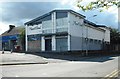
The Hazel Wood Bar
At the junction of Nitshill Road and Dove Street.
Image: © Richard Sutcliffe
Taken: 6 Sep 2018
0.01 miles
2
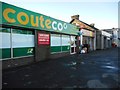
Shops at Nitshill
Coute Co, Thai Sun and BetFred.
Image: © Richard Sutcliffe
Taken: 29 Jan 2018
0.02 miles
3
Looking towards Nitshill Road
This short piece of road runs down the side of Coute Co (one of the shops on the main road).
Image: © Richard Sutcliffe
Taken: 29 Jan 2018
0.02 miles
4
Hanover Close, 8 Dove Street
34 sheltered housing flats for over sixties, built in 1980.
Image: © Richard Sutcliffe
Taken: 6 Sep 2018
0.02 miles
5

Masonic Lodge, Nitshill, Glasgow.
Lodge Nitshill No.1478, Nitshill, Glasgow.
Image: © Jim Campbell
Taken: 8 Dec 2008
0.03 miles
6
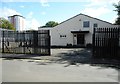
Masonic Lodge, Nitshill
Lodge No 1478 on Dove Street.
Image: © Richard Sutcliffe
Taken: 6 Sep 2018
0.03 miles
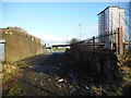
7
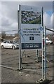
Planned development beside Nitshill Road
Sign advertising a proposed new housing development on waste ground beside Nitshill Station, to be called Station Wynd.
Image: © Richard Sutcliffe
Taken: 6 Mar 2017
0.05 miles
8
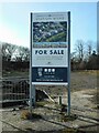
Station Wynd
Sign advertising a proposed new housing development on waste ground beside Nitshill Station. Compare this with an earlier version from 2017 Image
Image: © Richard Sutcliffe
Taken: 23 Feb 2023
0.05 miles
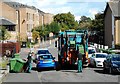
10
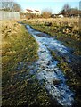
Icy path, Nitshill
Path across 'waste ground' leading to Nitshill Road. The path was frozen and numerous walkers had broken up much of the ice.
Image: © Richard Sutcliffe
Taken: 15 Dec 2017
0.06 miles