IMAGES TAKEN NEAR TO
Greenacres Drive, GLASGOW, G53 7BB
Introduction
This page details the photographs taken nearby to Greenacres Drive, G53 7BB by members of the Geograph project.
The Geograph project started in 2005 with the aim of publishing, organising and preserving representative images for every square kilometre of Great Britain, Ireland and the Isle of Man.

There are currently over 7.5m images from over14,400 individuals and you can help contribute to the project by visiting https://www.geograph.org.uk
Image Map
Images are licensed for reuse under creativecommons.org/licenses/by-sa/2.0
Notes
- Clicking on the map will re-center to the selected point.
- The higher the marker number, the further away the image location is from the centre of the postcode.
Image Listing (29 Images Found)
Images are licensed for reuse under creativecommons.org/licenses/by-sa/2.0
Image
Details
Distance
1
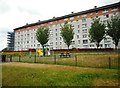
Flats on Glen Clunie Place
Seen from Greenacres Drive.
Image: © Richard Sutcliffe
Taken: 16 Jul 2018
0.05 miles
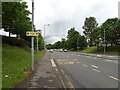
2
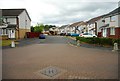
Glen Kyle Drive
Seen from Greenacres Drive.
Image: © Richard Sutcliffe
Taken: 16 Jul 2018
0.06 miles
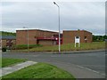
4
Darnley Primary School
From Glen Moriston Road.
Image: © Stephen Sweeney
Taken: 25 May 2009
0.12 miles
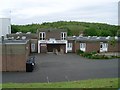
6
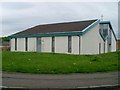
Darnley church
On Glen Moriston Road.
Image: © Stephen Sweeney
Taken: 25 May 2009
0.14 miles
7
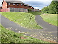
Footpaths behind Glen Esk Drive
Junction of paths leading from Nitshill Road (A726). The one on the left joins Glen Esk Drive. The one on the right runs behind between the houses and the Brock Burn (just out of shot to the right of the trees).
Image: © Richard Sutcliffe
Taken: 30 Jun 2015
0.14 miles
8
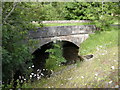
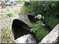
Old tram bridge over the Brock Burn
This bridge was apparently built to carry a tram line for the Paisley District Tramways Company over the Brock Burn in 1910. It now carries a footpath across the burn.
The plant in the middle is Giant Hogweed (Heracleum mantegazzianum).
Image: © Richard Sutcliffe
Taken: 30 Jun 2015
0.15 miles
9
Darnley Bridge
The A726 Nitshill Road crosses the Brock Burn at this point. The photograph was taken from the adjacent old tram bridge.
The plant in the middle is Giant Hogweed (Heracleum mantegazzianum).
Image: © Richard Sutcliffe
Taken: 30 Jun 2015
0.15 miles
10
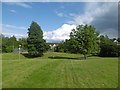
Park off Nitshill Road
Beside the Levern Water.
Image: © Richard Webb
Taken: 25 Jun 2016
0.16 miles