IMAGES TAKEN NEAR TO
Cleeves Road, GLASGOW, G53 6SN
Introduction
This page details the photographs taken nearby to Cleeves Road, G53 6SN by members of the Geograph project.
The Geograph project started in 2005 with the aim of publishing, organising and preserving representative images for every square kilometre of Great Britain, Ireland and the Isle of Man.

There are currently over 7.5m images from over14,400 individuals and you can help contribute to the project by visiting https://www.geograph.org.uk
Image Map
Images are licensed for reuse under creativecommons.org/licenses/by-sa/2.0
Notes
- Clicking on the map will re-center to the selected point.
- The higher the marker number, the further away the image location is from the centre of the postcode.
Image Listing (117 Images Found)
Images are licensed for reuse under creativecommons.org/licenses/by-sa/2.0
Image
Details
Distance
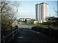
1
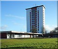
High rise flats on Nitshill Road
Several of the shop units beside the flats are closed.
Image: © Richard Sutcliffe
Taken: 29 Jan 2018
0.09 miles
2
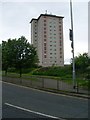
High flat in Priesthill
Next to Nitshill Road.
Image: © Stephen Sweeney
Taken: 25 May 2009
0.10 miles
3
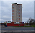
High Rise Block, Priesthill
Looking over Nitshill Road A726 to this apartment block with retail shops below.
Image: © wfmillar
Taken: 14 Mar 2012
0.10 miles
4
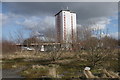
High rise flats on Nitshill Road
Seen from the waste ground near the station.
Image: © Richard Sutcliffe
Taken: 6 Mar 2017
0.11 miles
5
High Rise Flats and Nitshill Road
Seen from the ramp to Nitshill Station.
Image: © Richard Sutcliffe
Taken: 23 Feb 2023
0.11 miles
6
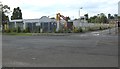
Former Arnold Clark showroom
The former Arnold Clark car showroom at the junction of Peat Road and Dunside Drive. The building has been derelict and boarded up for the last year or so, and the presence of excavators suggest it is about to be demolished.
Image: © Richard Sutcliffe
Taken: 10 Jul 2015
0.12 miles
7
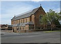
Catholic Church, Peat Road
The church is dedicated to St Robert Bellarmine (1542-1621), a Jesuit priest.
120 solar panels were installed on the roof in 2012, and the church also has a biomass boiler.
Image: © Richard Sutcliffe
Taken: 10 Jul 2015
0.12 miles
8
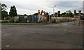
Former Arnold Clark showroom demolition
As predicted [http://www.geograph.org.uk/photo/4563624], this building is being demolished.
Image: © Richard Sutcliffe
Taken: 18 Aug 2015
0.12 miles
9
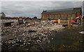
Remains of Arnold Clark showroom
The yellow Renault signs are the only obvious signs of what the building used to be before it was demolished [http://www.geograph.org.uk/photo/4563624].
St Robert Bellarmine Church is now more visible from this angle.
Image: © Richard Sutcliffe
Taken: 18 Aug 2015
0.12 miles
10
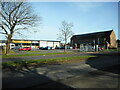
Farmfoods and St Robert Bellarmine Church
The Roman Catholic church is dedicated to St Robert Bellarmine (1542-1621), a Jesuit priest.
Image: © Richard Sutcliffe
Taken: 23 Feb 2023
0.12 miles