IMAGES TAKEN NEAR TO
Shilton Drive, GLASGOW, G53 6QF
Introduction
This page details the photographs taken nearby to Shilton Drive, G53 6QF by members of the Geograph project.
The Geograph project started in 2005 with the aim of publishing, organising and preserving representative images for every square kilometre of Great Britain, Ireland and the Isle of Man.

There are currently over 7.5m images from over14,400 individuals and you can help contribute to the project by visiting https://www.geograph.org.uk
Image Map
Images are licensed for reuse under creativecommons.org/licenses/by-sa/2.0
Notes
- Clicking on the map will re-center to the selected point.
- The higher the marker number, the further away the image location is from the centre of the postcode.
Image Listing (9 Images Found)
Images are licensed for reuse under creativecommons.org/licenses/by-sa/2.0
Image
Details
Distance
1
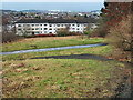
SUDS pond, Muirshiel Crescent
A sustainable drainage system designed to reduce the potential impact of a new development with respect to surface water drainage discharges.
Image: © Richard Sutcliffe
Taken: 14 Jun 2016
0.18 miles
2
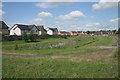
Houses on Linnhead Drive, Old Nitshill
The area up to the houses was the site of Victoria Pit, an ironstone pit that operated from 1843 to 1920. The last owner was Wm Baird & Co Ltd who worked the pit from 1895 to 1920. The area is now open parkland. See, https://maps.nls.uk/geo/explore/#zoom=16.6&lat=55.81527&lon=-4.35059&layers=168&b=1
Image: © wrobison
Taken: 14 Feb 2023
0.18 miles
3
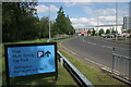
Car park this way
Road to the multi-storey car park, Silverburn shopping centre.
Image: © Richard Sutcliffe
Taken: 14 Jun 2016
0.23 miles
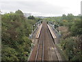
4
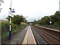
Priesthill & Darnley Railway Station
Line towards Nitshill.
Image: © JThomas
Taken: 14 Sep 2021
0.23 miles
5
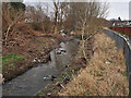
Brock Burn near the Silverburn Shopping Centre
Still the location for abandoned shopping trolleys and other discarded items, see Image
Image: © wrobison
Taken: 14 Feb 2023
0.23 miles
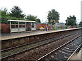
6
Priesthill & Darnley railway station, Glasgow
Opened in 1990 by British Rail on the line from Glasgow Central to Kilmarnock. View east towards Kennishead and Glasgow.
Image: © Nigel Thompson
Taken: 12 Oct 2013
0.24 miles
8
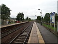
Priesthill & Darnley Railway Station
Line east towards Kennishead and Glasgow.
Image: © JThomas
Taken: 14 Sep 2021
0.25 miles
9
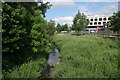
Brock Burn
Beside the Silverburn shopping centre.
Image: © Richard Sutcliffe
Taken: 14 Jun 2016
0.25 miles