IMAGES TAKEN NEAR TO
Burnbrae Gardens, GLASGOW, G53 6NZ
Introduction
This page details the photographs taken nearby to Burnbrae Gardens, G53 6NZ by members of the Geograph project.
The Geograph project started in 2005 with the aim of publishing, organising and preserving representative images for every square kilometre of Great Britain, Ireland and the Isle of Man.

There are currently over 7.5m images from over14,400 individuals and you can help contribute to the project by visiting https://www.geograph.org.uk
Image Map
Images are licensed for reuse under creativecommons.org/licenses/by-sa/2.0
Notes
- Clicking on the map will re-center to the selected point.
- The higher the marker number, the further away the image location is from the centre of the postcode.
Image Listing (19 Images Found)
Images are licensed for reuse under creativecommons.org/licenses/by-sa/2.0
Image
Details
Distance
1
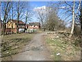
Path beside the Brock Burn
The place to go for all things smashed and burnt out. You can also marvel at the shopping trolleys in the Brock Burn. Best visited on a cold morning when hardly anyone is about. If cycling, good tyres are a must, as you will spend a lot of time on glass.
Image: © Richard Webb
Taken: 9 Apr 2013
0.05 miles
2
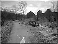
Path beside the Brock Burn
A foot and cycle path for those intrepid enough to trust their tyres on broken glass. There is what appears to be a burnt out divan beside the bed.
Image: © Richard Webb
Taken: 9 Apr 2013
0.05 miles
3

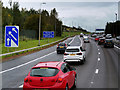
Green car park, Silverburn
The Brock Burn runs just beyond the trees on the right.
Image: © Richard Sutcliffe
Taken: 14 Jun 2016
0.10 miles
4
Brock Burn
Prime shopping trolley habitat. There must have been over a hundred in the burn upstream from Silverburn Shopping Centre. Perhaps they are spawning?
A path runs alongside the burn and gives a traffic free cycle route if you are willing to brave the broken glass. I got away with it.
Image: © Richard Webb
Taken: 9 Apr 2013
0.13 miles
5
Green car park, Silverburn
Looking towards the shopping centre.
Image: © Richard Sutcliffe
Taken: 14 Jun 2016
0.14 miles
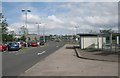
6
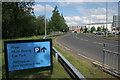
Car park this way
Road to the multi-storey car park, Silverburn shopping centre.
Image: © Richard Sutcliffe
Taken: 14 Jun 2016
0.14 miles

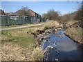
9
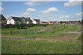
SUDS pond, Muirshiel Crescent
A sustainable drainage system designed to reduce the potential impact of a new development with respect to surface water drainage discharges.
Image: © Richard Sutcliffe
Taken: 14 Jun 2016
0.18 miles
10
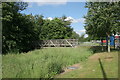
Bridge over the Brock Burn
Across the road from Silverburn shopping centre.
Image: © Richard Sutcliffe
Taken: 14 Jun 2016
0.19 miles