IMAGES TAKEN NEAR TO
Cleeves Quadrant, GLASGOW, G53 6NR
Introduction
This page details the photographs taken nearby to Cleeves Quadrant, G53 6NR by members of the Geograph project.
The Geograph project started in 2005 with the aim of publishing, organising and preserving representative images for every square kilometre of Great Britain, Ireland and the Isle of Man.

There are currently over 7.5m images from over14,400 individuals and you can help contribute to the project by visiting https://www.geograph.org.uk
Image Map
Images are licensed for reuse under creativecommons.org/licenses/by-sa/2.0
Notes
- Clicking on the map will re-center to the selected point.
- The higher the marker number, the further away the image location is from the centre of the postcode.
Image Listing (126 Images Found)
Images are licensed for reuse under creativecommons.org/licenses/by-sa/2.0
Image
Details
Distance
1
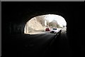
Looking out of the tunnel
Looking southeast from under the railway bridge over the A726, Nitshill Road.
Image: © Richard Sutcliffe
Taken: 6 Mar 2017
0.07 miles
2
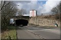
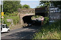
Railway bridge over the A726, Nitshill Road
Image: © Richard Sutcliffe
Taken: 6 Mar 2017
0.07 miles
3
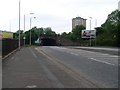
Tunnel under railway east of Nitshill Station
Allows Nitshill Road to underpass the railway.
Image: © Stephen Sweeney
Taken: 25 May 2009
0.08 miles
4
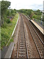
Railway, Nitshill Station
Looking east from the footbridge at Nitshill Station. Just beyond the platform, the railway crosses the A726, Nitshill Road.
Image: © Richard Sutcliffe
Taken: 24 Aug 2015
0.08 miles
5
Railway Bridge over Nitshill Road
The railway bridge seems large for the present day two-track railway which crosses it. This is because when built, there were also sidings crossing the bridge, and the short Victoria Branch Railway left the main line at this point, leading to the Victoria Pit coal mine.
Image: © Richard Sutcliffe
Taken: 11 Jun 2015
0.09 miles
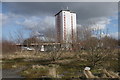
6
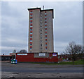
High rise flats on Nitshill Road
Several of the shop units beside the flats are closed.
Image: © Richard Sutcliffe
Taken: 29 Jan 2018
0.09 miles
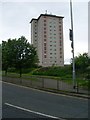
7
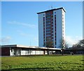
High Rise Block, Priesthill
Looking over Nitshill Road A726 to this apartment block with retail shops below.
Image: © wfmillar
Taken: 14 Mar 2012
0.09 miles
8
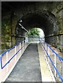
Start of the ramp to Platform 2
As part of the electrification of the line from Glasgow to Barrhead the bridge over the line Image had to be removed, due to limited clearance. As a consequence a new ramp has been constructed leading under the line, through an existing arch beside Nitshill Road and then up to platform height on the southern side of the station (platform 2). This is an improvement for disabled access, as there is now a ramped approach to both platforms.
Image: © Richard Sutcliffe
Taken: 1 Sep 2023
0.09 miles
9
High flat in Priesthill
Next to Nitshill Road.
Image: © Stephen Sweeney
Taken: 25 May 2009
0.10 miles
10
High rise flats on Nitshill Road
Seen from the waste ground near the station.
Image: © Richard Sutcliffe
Taken: 6 Mar 2017
0.10 miles