IMAGES TAKEN NEAR TO
Lunderston Drive, GLASGOW, G53 6JD
Introduction
This page details the photographs taken nearby to Lunderston Drive, G53 6JD by members of the Geograph project.
The Geograph project started in 2005 with the aim of publishing, organising and preserving representative images for every square kilometre of Great Britain, Ireland and the Isle of Man.

There are currently over 7.5m images from over14,400 individuals and you can help contribute to the project by visiting https://www.geograph.org.uk
Image Map
Images are licensed for reuse under creativecommons.org/licenses/by-sa/2.0
Notes
- Clicking on the map will re-center to the selected point.
- The higher the marker number, the further away the image location is from the centre of the postcode.
Image Listing (5 Images Found)
Images are licensed for reuse under creativecommons.org/licenses/by-sa/2.0
Image
Details
Distance
1
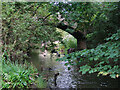
Bridge over Levern Water in Househill Park
The bridge was the main access to Househill mansion house. Househill was once the home of Kate Cranston, the tearoom owner. The building was demolished following a fire in 1939.
Image: © wrobison
Taken: 14 Aug 2023
0.18 miles
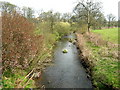
4
Glenlora Drive
The ground to the left is about to be developed for housing by Sanctuary Homes.
Image: © Richard Sutcliffe
Taken: 20 Oct 2017
0.23 miles
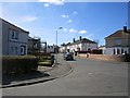
5

Shops on Barrhead Road
At Crookston Road.
Image: © Stephen Sweeney
Taken: 25 May 2009
0.24 miles