IMAGES TAKEN NEAR TO
Peat Road, GLASGOW, G53 6DE
Introduction
This page details the photographs taken nearby to Peat Road, G53 6DE by members of the Geograph project.
The Geograph project started in 2005 with the aim of publishing, organising and preserving representative images for every square kilometre of Great Britain, Ireland and the Isle of Man.

There are currently over 7.5m images from over14,400 individuals and you can help contribute to the project by visiting https://www.geograph.org.uk
Image Map
Images are licensed for reuse under creativecommons.org/licenses/by-sa/2.0
Notes
- Clicking on the map will re-center to the selected point.
- The higher the marker number, the further away the image location is from the centre of the postcode.
Image Listing (7 Images Found)
Images are licensed for reuse under creativecommons.org/licenses/by-sa/2.0
Image
Details
Distance
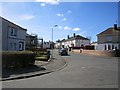
1
Peat Road, Priesthill
One of several dual carriageway residential roads in this part of southwest Glasgow.
Image: © Richard Webb
Taken: 9 Apr 2013
0.13 miles
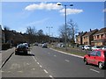
2
Peat Road
Looking along Peat Road towards Nitshill.
Image: © Richard Sutcliffe
Taken: 30 Apr 2015
0.15 miles
3
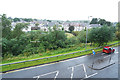
View from the car park
Looking out from the multi-storey carpark at Silverburn shopping centre in the pouring rain.
Image: © Malcolm Neal
Taken: 30 Aug 2019
0.21 miles
4
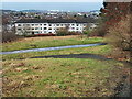
Houses on Linnhead Drive, Old Nitshill
The area up to the houses was the site of Victoria Pit, an ironstone pit that operated from 1843 to 1920. The last owner was Wm Baird & Co Ltd who worked the pit from 1895 to 1920. The area is now open parkland. See, https://maps.nls.uk/geo/explore/#zoom=16.6&lat=55.81527&lon=-4.35059&layers=168&b=1
Image: © wrobison
Taken: 14 Feb 2023
0.23 miles
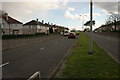
5
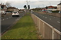
Peat Road
Pedestrian crossing on Peat Road.
Image: © Richard Sutcliffe
Taken: 30 Apr 2015
0.24 miles