IMAGES TAKEN NEAR TO
Drums Road, GLASGOW, G53 5YF
Introduction
This page details the photographs taken nearby to Drums Road, G53 5YF by members of the Geograph project.
The Geograph project started in 2005 with the aim of publishing, organising and preserving representative images for every square kilometre of Great Britain, Ireland and the Isle of Man.

There are currently over 7.5m images from over14,400 individuals and you can help contribute to the project by visiting https://www.geograph.org.uk
Image Map
Images are licensed for reuse under creativecommons.org/licenses/by-sa/2.0
Notes
- Clicking on the map will re-center to the selected point.
- The higher the marker number, the further away the image location is from the centre of the postcode.
Image Listing (46 Images Found)
Images are licensed for reuse under creativecommons.org/licenses/by-sa/2.0
Image
Details
Distance
1
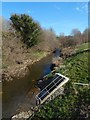
The Levern Water
The view is from the road bridge that carries Linthaugh Road over the river.
Image: © Lairich Rig
Taken: 24 Mar 2014
0.10 miles
2
White Cart Water
Looking along the river from the footbridge in Rosshall Park.
Image: © Richard Webb
Taken: 16 Jun 2009
0.12 miles
3
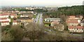
View from Crookston Castle - NNE
The viewpoint for this picture was the top of Crookston Castle, and the view is towards South Cardonald.
The main road that is prominent at the centre of the image is Lyoncross Road. The line of distant towerblocks to the right of centre is located at Moss Heights Avenue. The area of woodland filling the middle distance in the right-hand side of the image is Crookston Wood.
Image: © Lairich Rig
Taken: 9 Dec 2005
0.14 miles
4
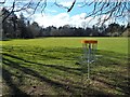
Rosshall Park
The nearby object is one of several targets for Disc Golf, a flying-disc game.
For other views of the park, see http://www.geograph.org.uk/tagged/Rosshall+Park#photo=3947699 (several images), and also Image
Image: © Lairich Rig
Taken: 24 Mar 2014
0.14 miles
5
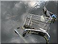
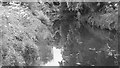
Heading for the spawning grounds
The White Cart still has a healthy run of shopping trolley. They can often be seen by the observant from bridges or riverside paths.
Image: © Richard Webb
Taken: 16 Jun 2009
0.15 miles
6
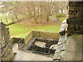
Position of causeway in Crookston Castle's ringworks
This picture was taken from an upper floor of Crookston Castle; see the main description: Image The existing ruined castle dates from the early fifteenth century, but the defensive earthworks were associated with an earlier (twelfth century) wooden structure that stood on the same site.
As was mentioned in the main description, the position of an original causeway in the defensive ringwork that surrounds the castle site can still be discerned today. The defensive ditch is clearly visible here, but note a path that crosses it near the position of the red van (which is parked in front of a nearby lodge). It is at this point, where the path crosses the ditch, that the original causeway would have been located.
In this image, on the near side of the ditch, just to the right of the path, it is just possible to make out something set into the grass. This is a plaque on a stone, and it reads:
"Gatehouse - This is where the gatehouse would always have stood. The first Crookston Castle was built by Robert Croc, who gave his name to the area, before 1180. You can still see the mighty bank and ditch which protected his timber hall, kitchen, bakehouse and stables. The stone castle was built by the Stewarts of Darnley around 1400. This is a carefully planned tower house, with a smaller symmetrical tower at each corner. The castle was damaged in a siege in 1489, and although partially rebuilt was in ruins by 1600."
Image: © Lairich Rig
Taken: 9 Dec 2005
0.16 miles
7
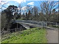
Footbridge over the White Cart Water
See Image for another view of this bridge, which leads into Rosshall Park.
Image: © Lairich Rig
Taken: 24 Mar 2014
0.16 miles
8
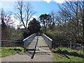
Footbridge over the White Cart Water
Followed in this direction, the bridge leads into Rosshall Park. See Image for a side view.
Image: © Lairich Rig
Taken: 24 Mar 2014
0.17 miles
9
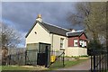
Cottage at entrance to Crookston Castle, Glasgow
Image: © Leslie Barrie
Taken: 27 Apr 2013
0.17 miles
10
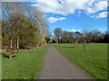
Rosshall Park
See http://www.geograph.org.uk/tagged/Rosshall+Park#photo=3947699 for other pictures of the park and gardens.
Image: © Lairich Rig
Taken: 24 Mar 2014
0.18 miles