IMAGES TAKEN NEAR TO
Linthaugh Road, GLASGOW, G53 5YE
Introduction
This page details the photographs taken nearby to Linthaugh Road, G53 5YE by members of the Geograph project.
The Geograph project started in 2005 with the aim of publishing, organising and preserving representative images for every square kilometre of Great Britain, Ireland and the Isle of Man.

There are currently over 7.5m images from over14,400 individuals and you can help contribute to the project by visiting https://www.geograph.org.uk
Image Map
Images are licensed for reuse under creativecommons.org/licenses/by-sa/2.0
Notes
- Clicking on the map will re-center to the selected point.
- The higher the marker number, the further away the image location is from the centre of the postcode.
Image Listing (23 Images Found)
Images are licensed for reuse under creativecommons.org/licenses/by-sa/2.0
Image
Details
Distance
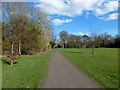
1
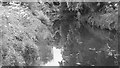
White Cart Water
Looking along the river from the footbridge in Rosshall Park.
Image: © Richard Webb
Taken: 16 Jun 2009
0.11 miles
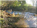
2
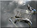
Heading for the spawning grounds
The White Cart still has a healthy run of shopping trolley. They can often be seen by the observant from bridges or riverside paths.
Image: © Richard Webb
Taken: 16 Jun 2009
0.13 miles
3
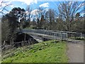
Footbridge over the White Cart Water
See Image for another view of this bridge, which leads into Rosshall Park.
Image: © Lairich Rig
Taken: 24 Mar 2014
0.14 miles
4
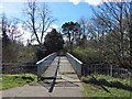
Footbridge over the White Cart Water
Followed in this direction, the bridge leads into Rosshall Park. See Image for a side view.
Image: © Lairich Rig
Taken: 24 Mar 2014
0.15 miles
5
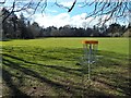
Rosshall Park
The nearby object is one of several targets for Disc Golf, a flying-disc game.
For other views of the park, see http://www.geograph.org.uk/tagged/Rosshall+Park#photo=3947699 (several images), and also Image
Image: © Lairich Rig
Taken: 24 Mar 2014
0.15 miles
6
Small Waterfall on the White Cart Water
Looking up-river just north of Pollok.
Image: © G Laird
Taken: 4 Nov 2013
0.15 miles
7
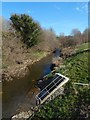
The Levern Water
The view is from the road bridge that carries Linthaugh Road over the river.
Image: © Lairich Rig
Taken: 24 Mar 2014
0.16 miles
8
Rosshall Park
See http://www.geograph.org.uk/tagged/Rosshall+Park#photo=3947699 for other pictures of the park and gardens.
Image: © Lairich Rig
Taken: 24 Mar 2014
0.17 miles
9
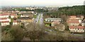
View from Crookston Castle - NNE
The viewpoint for this picture was the top of Crookston Castle, and the view is towards South Cardonald.
The main road that is prominent at the centre of the image is Lyoncross Road. The line of distant towerblocks to the right of centre is located at Moss Heights Avenue. The area of woodland filling the middle distance in the right-hand side of the image is Crookston Wood.
Image: © Lairich Rig
Taken: 9 Dec 2005
0.18 miles
10
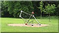
Climbing frame, Rosshall Park
Or a molecular model of some exotic complex.
Image: © Richard Webb
Taken: 16 Jun 2009
0.19 miles