
IMAGES TAKEN NEAR TO
Lyoncross Road, GLASGOW, G53 5UT
Introduction
This page details the photographs taken nearby to Lyoncross Road, G53 5UT by members of the Geograph project.
The Geograph project started in 2005 with the aim of publishing, organising and preserving representative images for every square kilometre of Great Britain, Ireland and the Isle of Man.

There are currently over 7.5m images from over14,400 individuals and you can help contribute to the project by visiting https://www.geograph.org.uk
Image Map
Images are licensed for reuse under creativecommons.org/licenses/by-sa/2.0
Notes
- Clicking on the map will re-center to the selected point.
- The higher the marker number, the further away the image location is from the centre of the postcode.
Image Listing (47 Images Found)
Images are licensed for reuse under creativecommons.org/licenses/by-sa/2.0
Image
Details
Distance

2
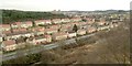
View from Crookston Castle - ENE
The viewpoint for this picture was the top of Crookston Castle, and the view is towards the Pollok and Corkerhill areas of Glasgow.
The main road visible at the bottom of the image is Lyoncross Road; between this road and the unseen Potterhill Road (higher up the slope) are two rows of houses. Between Potterhill Road and Barnbeth Road (higher up again) are another two rows of houses. There are no houses on the far side of Barnbeth Road, but Crookston Wood begins there; this wood can be seen in the photo.
Image: © Lairich Rig
Taken: 9 Dec 2005
0.07 miles
3
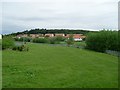
Pollok
Looking to Lyoncross Road from beside the footbridge over the Levern Water.
Image: © Stephen Sweeney
Taken: 25 May 2009
0.07 miles
4
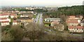
View from Crookston Castle - NNE
The viewpoint for this picture was the top of Crookston Castle, and the view is towards South Cardonald.
The main road that is prominent at the centre of the image is Lyoncross Road. The line of distant towerblocks to the right of centre is located at Moss Heights Avenue. The area of woodland filling the middle distance in the right-hand side of the image is Crookston Wood.
Image: © Lairich Rig
Taken: 9 Dec 2005
0.09 miles
5

Barnbeth Road
With Crookston Wood on the left, part of the Stirling Maxwell Forest Park.
Image: © Richard Sutcliffe
Taken: 25 Sep 2025
0.09 miles
6

Shops on Lyoncross Road
Including One-O-One (convenience store); Hair Couture; Lyoncross Pharmacy; and U-Save (convenience store), including a post office counter.
Image: © Richard Sutcliffe
Taken: 25 Sep 2025
0.10 miles
7

Lyoncross Road
With central grassy strip.
Image: © Richard Sutcliffe
Taken: 25 Sep 2025
0.11 miles
8
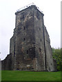
The NE tower of Crookston Castle
This tower is the only part of the castle which still survives to its original height.
Image: © Stephen Sweeney
Taken: 13 May 2010
0.11 miles
9

Crookston Wood
Part of the Stirling Maxwell Forest Park.
Image: © Richard Sutcliffe
Taken: 25 Sep 2025
0.11 miles
10
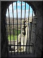
Crookston Castle: window of uppermost room
For the room, see Image This window is, with respect to that picture, out of shot to the right. It is also the higher of the two barred openings that can be seen high on the left in a picture of Image
I have called it a window (it now overlooks a sheer drop above the Great Hall), but it would originally have been a doorway leading onto a floor (now long gone) in the centre of the castle.
Image: © Lairich Rig
Taken: 24 Mar 2014
0.12 miles