IMAGES TAKEN NEAR TO
Lyoncross Road, GLASGOW, G53 5UL
Introduction
This page details the photographs taken nearby to Lyoncross Road, G53 5UL by members of the Geograph project.
The Geograph project started in 2005 with the aim of publishing, organising and preserving representative images for every square kilometre of Great Britain, Ireland and the Isle of Man.

There are currently over 7.5m images from over14,400 individuals and you can help contribute to the project by visiting https://www.geograph.org.uk
Image Map
Images are licensed for reuse under creativecommons.org/licenses/by-sa/2.0
Notes
- Clicking on the map will re-center to the selected point.
- The higher the marker number, the further away the image location is from the centre of the postcode.
Image Listing (10 Images Found)
Images are licensed for reuse under creativecommons.org/licenses/by-sa/2.0
Image
Details
Distance
1
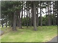
Pine wood, Linthaugh Road
Mature pines at the junction between Linthaugh and Lyoncross Road.
Image: © Richard Webb
Taken: 16 Jun 2009
0.05 miles
2
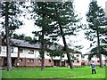
Possible dangerous tree
There had been high winds in January 2005 and trees around the country were being blown down, This particular tree I came across in Lyoncross Road, Pollok, Glasgow. The tree was sitting at an unusual angle and I was concerned about the potential damage that it would cause to the buildings or possibly pedestrians, a specialist inspected the tree and the result was that it was safe and the angle of the tree was not due to the high winds.
Image: © Stevie Spiers
Taken: 24 Jan 2005
0.07 miles
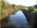
3
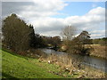
White Cart Water Near Mosspark Station
Image: © Iain Thompson
Taken: 17 Mar 2006
0.07 miles
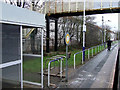
4
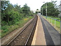
Mosspark railway station, Glasgow
Opened in 1934 by the London Midland & Scottish Railway on its line from Glasgow to Elderslie via Paisley Canal, this station closed in 1983 and then reopened in 1990 with the line. Taken just before the line was electrified.
Image: © Nigel Thompson
Taken: 28 Jul 2012
0.10 miles
5
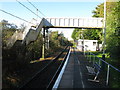
Mosspark Railway Station
The station between Crookston and Corkerhill on the Paisley Canal Line.
Image: © G Laird
Taken: 4 Nov 2013
0.11 miles
6
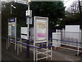
Mosspark railway station
On the Paisley Canal Line, between Corkerhill and Crookston.
Image: © Thomas Nugent
Taken: 8 Dec 2012
0.12 miles
7
Mosspark railway station
On the Paisley Canal Line, between Corkerhill and Crookston.
Image: © Thomas Nugent
Taken: 8 Dec 2012
0.12 miles
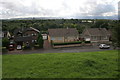
8
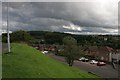
Dundee Drive
Looking down on Dundee Drive from Angus Oval. The woodland on the horizon is Crookston Wood.
Image: © Richard Sutcliffe
Taken: 26 Aug 2015
0.17 miles
9
White Cart Water at South Cardonald
Looking up-river from the footbridge over the river beside Mosspark railway station.
Image: © G Laird
Taken: 4 Nov 2013
0.18 miles
10
Dundee Drive
Looking down from Angus Oval onto Dundee Drive.
Image: © Richard Sutcliffe
Taken: 26 Aug 2015
0.21 miles