IMAGES TAKEN NEAR TO
Templeland Road, GLASGOW, G53 5PF
Introduction
This page details the photographs taken nearby to Templeland Road, G53 5PF by members of the Geograph project.
The Geograph project started in 2005 with the aim of publishing, organising and preserving representative images for every square kilometre of Great Britain, Ireland and the Isle of Man.

There are currently over 7.5m images from over14,400 individuals and you can help contribute to the project by visiting https://www.geograph.org.uk
Image Map
Images are licensed for reuse under creativecommons.org/licenses/by-sa/2.0
Notes
- Clicking on the map will re-center to the selected point.
- The higher the marker number, the further away the image location is from the centre of the postcode.
Image Listing (12 Images Found)
Images are licensed for reuse under creativecommons.org/licenses/by-sa/2.0
Image
Details
Distance
1
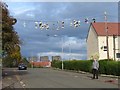
Sports shoes on a phone line
The sports shoes were thrown up by local youths after playing in a football tournament to celebrate the life of a local Pollok boy who was killed in Iraq. The shoes had to be removed much to the displeasure by the local youths as the weight of them would have eventually brought the line down. This photograph was taken looking up Hapland Avenue in Pollok, Glasgow, the blocks of flats in the distance are in Cardonald, Glasgow.
Image: © Stevie Spiers
Taken: 17 Oct 2004
0.07 miles
2
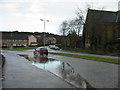
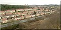
Lyoncross Road, Pollok
This corner always had a puddle when it rained, it may have a drain now.
Image: © Stevie Spiers
Taken: 20 Jan 2005
0.16 miles
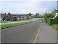
4
Linthaugh Road
Waiting for a bus in Pollok.
Image: © Richard Webb
Taken: 16 Jun 2009
0.20 miles
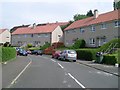
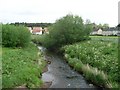
5
Pollok
Looking to Lyoncross Road from beside the footbridge over the Levern Water.
Image: © Stephen Sweeney
Taken: 25 May 2009
0.21 miles
6
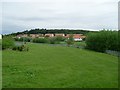
View from Crookston Castle - ENE
The viewpoint for this picture was the top of Crookston Castle, and the view is towards the Pollok and Corkerhill areas of Glasgow.
The main road visible at the bottom of the image is Lyoncross Road; between this road and the unseen Potterhill Road (higher up the slope) are two rows of houses. Between Potterhill Road and Barnbeth Road (higher up again) are another two rows of houses. There are no houses on the far side of Barnbeth Road, but Crookston Wood begins there; this wood can be seen in the photo.
Image: © Lairich Rig
Taken: 9 Dec 2005
0.21 miles
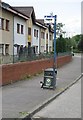
7
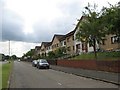
Linthaugh Road
Houses alongside the very quiet Linthaugh Road dual carriageway.
Image: © Richard Webb
Taken: 16 Jun 2009
0.22 miles
8
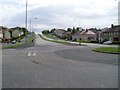
Braidcraft Road, Pollok
Looking east along one of Pollok's main roads from the roundabout at Levernside Road.
Image: © Stephen Sweeney
Taken: 25 May 2009
0.22 miles
10
Levern Water
From the footbridge in Pollok.
Image: © Stephen Sweeney
Taken: 25 May 2009
0.22 miles