IMAGES TAKEN NEAR TO
Drumcross Road, GLASGOW, G53 5LN
Introduction
This page details the photographs taken nearby to Drumcross Road, G53 5LN by members of the Geograph project.
The Geograph project started in 2005 with the aim of publishing, organising and preserving representative images for every square kilometre of Great Britain, Ireland and the Isle of Man.

There are currently over 7.5m images from over14,400 individuals and you can help contribute to the project by visiting https://www.geograph.org.uk
Image Map
Images are licensed for reuse under creativecommons.org/licenses/by-sa/2.0
Notes
- Clicking on the map will re-center to the selected point.
- The higher the marker number, the further away the image location is from the centre of the postcode.
Image Listing (18 Images Found)
Images are licensed for reuse under creativecommons.org/licenses/by-sa/2.0
Image
Details
Distance
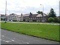
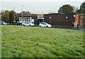
2
Playing field
Between Langton Road and Langton Crescent.
Image: © Richard Sutcliffe
Taken: 14 Oct 2019
0.11 miles
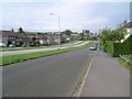
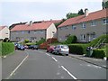
4
Braidcraft Road, Pollok
Looking east along one of Pollok's main roads from the roundabout at Levernside Road.
Image: © Stephen Sweeney
Taken: 25 May 2009
0.12 miles
5
St Marnock's R C Primary School
On Langton Crescent.
Image: © Richard Sutcliffe
Taken: 14 Oct 2019
0.15 miles
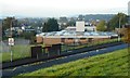
7
Pollok Community Centre
On Langton Road.
Image: © Richard Sutcliffe
Taken: 14 Oct 2019
0.18 miles
8

Netball court
Beside Langton Crescent.
Image: © Richard Sutcliffe
Taken: 14 Oct 2019
0.19 miles
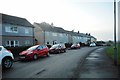
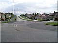
10
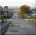
Looking down Langton Road
The distinctive outline of the top of Cineworld at Silverburn Shopping Centre can be seen in the distance.
Image: © Richard Sutcliffe
Taken: 14 Oct 2019
0.20 miles