IMAGES TAKEN NEAR TO
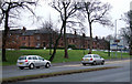
Meikle Road, GLASGOW, G53 5JD
Introduction
This page details the photographs taken nearby to Meikle Road, G53 5JD by members of the Geograph project.
The Geograph project started in 2005 with the aim of publishing, organising and preserving representative images for every square kilometre of Great Britain, Ireland and the Isle of Man.

There are currently over 7.5m images from over14,400 individuals and you can help contribute to the project by visiting https://www.geograph.org.uk
Image Map
Images are licensed for reuse under creativecommons.org/licenses/by-sa/2.0
Notes
- Clicking on the map will re-center to the selected point.
- The higher the marker number, the further away the image location is from the centre of the postcode.
Image Listing (76 Images Found)
Images are licensed for reuse under creativecommons.org/licenses/by-sa/2.0
Image
Details
Distance
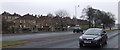
1

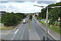
Barrhead Road
Looking towards Maidland Road.
Image: © Thomas Nugent
Taken: 9 Feb 2013
0.06 miles
2
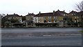
Barrhead Road
With the red sandstone houses on Carnock Road and Maidland Road beyond.
Image: © Thomas Nugent
Taken: 9 Feb 2013
0.06 miles
3
Barrhead Road
With the bridge over the Brock Burn and the houses on Carnock Road in the background.
Image: © Thomas Nugent
Taken: 9 Feb 2013
0.07 miles
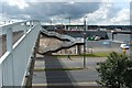
4
Barrhead Road
The picture was taken from a Image; that footbridge is now long gone, replaced by a pedestrian crossing at traffic lights. 300 metres ahead is Image; the roundabout itself is not clearly visible from here, but a large glass-fronted building can be seen near it: Image
For the view in the opposite direction from the same footbridge, see Image
Image: © Lairich Rig
Taken: 2 Sep 2005
0.07 miles
5
Barrhead Road
With the bridge over the Brock Burn and the houses on Carnock Road in the background.
Image: © Thomas Nugent
Taken: 9 Feb 2013
0.08 miles
6
Footbridge over Barrhead Road
The footbridge shown here is no longer present; it was gone by the end of 2006.
At the time when I took the picture, the buildings on the far side included the Pollok Centre. The area has been redeveloped since then. On this occasion, I was crossing the bridge while on the way to the Pollok Kist (a community museum that I visited on the day), which is still based nearby.
The footbridge was in line with the eastern side of Maidland Street (which is just to the north). A set of present-day traffic lights and a pedestrian crossing on Barrhead Road are where the footbridge used to be.
Note the cleared area directly ahead, on the far side of the bridge; construction was then taking place: Image / Image What was being built was the Silverburn Shopping Centre, which opened a few years later: Image
For views of the main road from the footbridge, see Image and Image
Image: © Lairich Rig
Taken: 2 Sep 2005
0.09 miles
7
Silverburn shopping centre
A large modern shopping mall by the M77 motorway at Pollok http://www.shopsilverburn.com/ . This is the older, outdoor part of the mall, which was originally Pollok shopping centre.
The burn in the foreground is the Brock Burn.
Image: © Thomas Nugent
Taken: 9 Feb 2013
0.09 miles
8
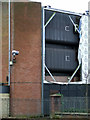
Silverburn shopping centre
A large modern shopping mall by the M77 motorway at Pollok http://www.shopsilverburn.com/ . This is the older, outdoor part of the mall, which was originally Pollok shopping centre. Note the faded "Polok" on the top floor where the screen material has fallen away.
Image: © Thomas Nugent
Taken: 9 Feb 2013
0.09 miles
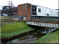
10
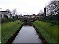
The Brock Burn
Running between Silverburn shopping centre and Pollok bus station.
Image: © Thomas Nugent
Taken: 9 Feb 2013
0.10 miles