IMAGES TAKEN NEAR TO
Libo Avenue, GLASGOW, G53 5ED
Introduction
This page details the photographs taken nearby to Libo Avenue, G53 5ED by members of the Geograph project.
The Geograph project started in 2005 with the aim of publishing, organising and preserving representative images for every square kilometre of Great Britain, Ireland and the Isle of Man.

There are currently over 7.5m images from over14,400 individuals and you can help contribute to the project by visiting https://www.geograph.org.uk
Image Map
Images are licensed for reuse under creativecommons.org/licenses/by-sa/2.0
Notes
- Clicking on the map will re-center to the selected point.
- The higher the marker number, the further away the image location is from the centre of the postcode.
Image Listing (25 Images Found)
Images are licensed for reuse under creativecommons.org/licenses/by-sa/2.0
Image
Details
Distance
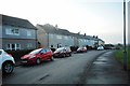
1
White Cart Water
View from Corkerhill Road.
Image: © Richard Webb
Taken: 16 Jun 2009
0.08 miles
2
Co-operative Foodstore, Pollok
At Braidcraft Terrace.
Image: © Stephen Sweeney
Taken: 25 May 2009
0.08 miles
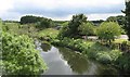
3
White Cart Water, Pollok Country Park
Viewed from Corkerhill Road.
Image: © Stephen Sweeney
Taken: 25 May 2009
0.08 miles
4
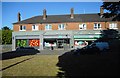
Shops, Braidcraft Terrace
Co-op and newsagent. There is also a butchers and a chemist.
Image: © Richard Sutcliffe
Taken: 26 Jul 2018
0.09 miles
5
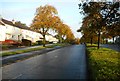
Braidcraft Road, Pollok
A very wide road.
Image: © Richard Webb
Taken: 25 Sep 2015
0.11 miles
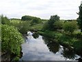
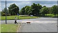
6
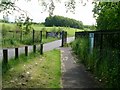
Entrance to Pollok Country Park
The entrance off Corkerhill Road.
Image: © Stephen Sweeney
Taken: 25 May 2009
0.12 miles
7
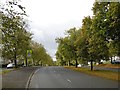
Braidcraft Road
Looking along the dual carriageway from the central reservation. The trees are displaying their autumn colours.
Image: © Richard Sutcliffe
Taken: 14 Oct 2019
0.13 miles
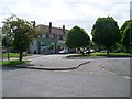
8
Roundabout, Braidcraft Road
A meeting point of some of Pollok's dual carriageways, seen from the saddle on Corkerhill Road. Despite appearances this was a warm fine day and there was no rain.
Image: © Richard Webb
Taken: 16 Jun 2009
0.13 miles
9
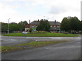
Roundabout in Pollok, Glasgow
The road to the left is a local road round Pollok. The road just to the left of the shops leads to Corkerhill and Mosspark while the road to the right leads towards the southern outskirts of Glasgow.
Image: © G Laird
Taken: 7 Nov 2013
0.14 miles