IMAGES TAKEN NEAR TO
Waterfoot Terrace, GLASGOW, G53 5BP
Introduction
This page details the photographs taken nearby to Waterfoot Terrace, G53 5BP by members of the Geograph project.
The Geograph project started in 2005 with the aim of publishing, organising and preserving representative images for every square kilometre of Great Britain, Ireland and the Isle of Man.

There are currently over 7.5m images from over14,400 individuals and you can help contribute to the project by visiting https://www.geograph.org.uk
Image Map
Images are licensed for reuse under creativecommons.org/licenses/by-sa/2.0
Notes
- Clicking on the map will re-center to the selected point.
- The higher the marker number, the further away the image location is from the centre of the postcode.
Image Listing (57 Images Found)
Images are licensed for reuse under creativecommons.org/licenses/by-sa/2.0
Image
Details
Distance
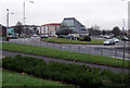
1

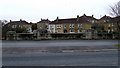
Barrhead Road
At Pollok Roundabout, with Waterfoot Terrace in the background.
Image: © Thomas Nugent
Taken: 9 Feb 2013
0.03 miles
2
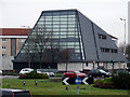
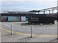
The Pollok Wedge
A community centre by Pollok Roundabout.
Image: © Thomas Nugent
Taken: 9 Feb 2013
0.05 miles
3
Pollok Roundabout
With the "Pollok Wedge" community centre beyond.
Image: © Thomas Nugent
Taken: 9 Feb 2013
0.05 miles
4

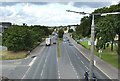
Barrhead Road
Looking towards Pollok Roundabout from the bridge over the Brock Burn.
Image: © Thomas Nugent
Taken: 9 Feb 2013
0.07 miles
5

CCTV camera at Pollok Roundabout
The camera appears to be pointing towards Silverburn shopping centre.
Image: © Thomas Nugent
Taken: 9 Feb 2013
0.07 miles
6
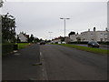
Levernside Road
Just off Braidcroft Road.
Image: © Richard Sutcliffe
Taken: 9 Jul 2015
0.08 miles
7
Barrhead Road
With the bridge over the Brock Burn and the houses on Carnock Road in the background.
Image: © Thomas Nugent
Taken: 9 Feb 2013
0.09 miles
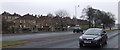
8
Barrhead Road
With the bridge over the Brock Burn and the houses on Carnock Road in the background.
Image: © Thomas Nugent
Taken: 9 Feb 2013
0.10 miles
9
Barrhead Road
The picture was taken from a Image; that footbridge is now long gone, replaced by a pedestrian crossing at traffic lights. 300 metres ahead is Image; the roundabout itself is not clearly visible from here, but a large glass-fronted building can be seen near it: Image
For the view in the opposite direction from the same footbridge, see Image
Image: © Lairich Rig
Taken: 2 Sep 2005
0.10 miles
10
Pollok Civic Realm
By the Silverburn Centre.
Image: © Barbara Carr
Taken: 22 Apr 2013
0.11 miles