IMAGES TAKEN NEAR TO
Cornaig Road, GLASGOW, G53 5AW
Introduction
This page details the photographs taken nearby to Cornaig Road, G53 5AW by members of the Geograph project.
The Geograph project started in 2005 with the aim of publishing, organising and preserving representative images for every square kilometre of Great Britain, Ireland and the Isle of Man.

There are currently over 7.5m images from over14,400 individuals and you can help contribute to the project by visiting https://www.geograph.org.uk
Image Map
Images are licensed for reuse under creativecommons.org/licenses/by-sa/2.0
Notes
- Clicking on the map will re-center to the selected point.
- The higher the marker number, the further away the image location is from the centre of the postcode.
Image Listing (5 Images Found)
Images are licensed for reuse under creativecommons.org/licenses/by-sa/2.0
Image
Details
Distance
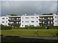
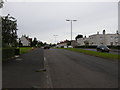
3
Netherplace Road
Flats off Netherplace Road, Pollok.
Image: © Richard Webb
Taken: 9 Apr 2013
0.15 miles
4
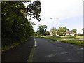
Barrhead Road
Dual carrieageway beside the Levern Water.
Image: © Richard Webb
Taken: 25 Sep 2015
0.18 miles
5
Levernside Road
Just off Braidcroft Road.
Image: © Richard Sutcliffe
Taken: 9 Jul 2015
0.23 miles