IMAGES TAKEN NEAR TO
Penilee Road, GLASGOW, G52 4UU
Introduction
This page details the photographs taken nearby to Penilee Road, G52 4UU by members of the Geograph project.
The Geograph project started in 2005 with the aim of publishing, organising and preserving representative images for every square kilometre of Great Britain, Ireland and the Isle of Man.

There are currently over 7.5m images from over14,400 individuals and you can help contribute to the project by visiting https://www.geograph.org.uk
Image Map
Images are licensed for reuse under creativecommons.org/licenses/by-sa/2.0
Notes
- Clicking on the map will re-center to the selected point.
- The higher the marker number, the further away the image location is from the centre of the postcode.
Image Listing (24 Images Found)
Images are licensed for reuse under creativecommons.org/licenses/by-sa/2.0
Image
Details
Distance
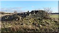
1
East Arkleston ruins: the northern buildings
See Image for the main description of the site, and click on the end-note title for more pictures. The present photograph is a wide-angle view, from inside the ruins, showing the entire line of the northern buildings, from the Image to the Image
Image: © Lairich Rig
Taken: 11 Jan 2014
0.11 miles
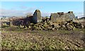
2

East Arkleston ruins: north-eastern corner
See Image for the main description of the site, and click on the end-note title for more pictures of it. On the background buildings, see Image
Image: © Lairich Rig
Taken: 11 Jan 2014
0.11 miles
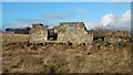
3
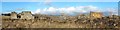
The ruins of East Arkleston
See Image for the main description. The present view shows the ruined farmstead from the west. The buildings behind it are in Hillington Industrial Estate; compare Image, taken from near the ruins.
Click on the end-note title for more pictures of the site.
Image: © Lairich Rig
Taken: 11 Jan 2014
0.12 miles
4
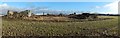
View to East Arkleston ruins
See Image for the main description of the ruins, and click on the end-note title for more pictures. The present view, a distant one, is intended to show the context of the ruins, which stand alone in a field (for which, see Image).
Image: © Lairich Rig
Taken: 11 Jan 2014
0.12 miles
5
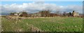
The ruins of East Arkleston
This is a view from the SSW, showing the entire width of the remains of East Arkleston. Click on the end-note title for more pictures of the ruins.
For a summary of the area, and for comments on the origin of the place-name, see Image The ruins of East Arkleston stand alone in a field; I am reluctant to cross fields, but no crop was growing at the time: see Image and Image (*)
The first map appearance of East Arkleston of which I am aware is the one mentioned in the end-note. Earlier maps depict only a single Arkleston; for example, Roy's Military Survey (1740s-50s) has "Erclostone".
Although East Arkleston was, by 2014, an unroofed ruin, enough of the walls survive to reveal the layout of the farmstead. The ruins stand alone in a field; the buildings of Image and Image can still be seen nearby, at the edge of the same field (for West Arkleston, see the summary given at Image).
(*) Scottish Outdoor Access Code (2005), 3.35 "Access where there are crops":
"You can exercise access rights on the margins of fields, even if these have been sown, and on any land in which crops have not been sown or are not growing. You can also exercise access rights in fields of stubble ...".
Image: © Lairich Rig
Taken: 11 Jan 2014
0.12 miles
6
East Arkleston ruins: south-western corner
See Image for the main description of the site. The detail shown in the present picture appears is at the far right in another picture: Image Click on the end-note title for more pictures.
Image: © Lairich Rig
Taken: 11 Jan 2014
0.12 miles
7
East Arkleston ruins: north-western building
This is a view from the west. The same building is shown from the south in Image In other words, the present picture shows what is, in the other picture, the unseen left-hand end.
See Image for the main description of the site, and click on the end-note title for other pictures of the ruins. For the background, see Image
Image: © Lairich Rig
Taken: 11 Jan 2014
0.12 miles
8
East Arkleston ruins: north-western building
See Image for the main description; in that picture, and in Image, this ruined farmhouse is at the far left. Click on the end-note title for more pictures of the ruins.
The trees in the left background are in Arkleston Cemetery: http://www.geograph.org.uk/snippet/10005
For a view towards what is, in the present picture, the unseen left-hand end of the building, see Image
Image: © Lairich Rig
Taken: 11 Jan 2014
0.12 miles
9
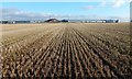
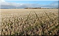
Stubble field at Arkleston
The picture was taken from near Image The buildings in the background are in Hillington Industrial Estate, on the far side of Penilee Road.
See Image for a view in the opposite direction from the same point.
Image: © Lairich Rig
Taken: 11 Jan 2014
0.13 miles
10
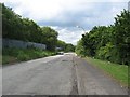
Gordon Avenue, Hillington Industrial Estate
Dumped rubbish seems to be a bigger hazard than potholes (Image). A dodgy looking undeveloped corner of Hillington Industrial Estate.
Image: © Richard Webb
Taken: 16 Jun 2009
0.17 miles