IMAGES TAKEN NEAR TO
Bowfield Drive, GLASGOW, G52 4HH
Introduction
This page details the photographs taken nearby to Bowfield Drive, G52 4HH by members of the Geograph project.
The Geograph project started in 2005 with the aim of publishing, organising and preserving representative images for every square kilometre of Great Britain, Ireland and the Isle of Man.

There are currently over 7.5m images from over14,400 individuals and you can help contribute to the project by visiting https://www.geograph.org.uk
Image Map
Images are licensed for reuse under creativecommons.org/licenses/by-sa/2.0
Notes
- Clicking on the map will re-center to the selected point.
- The higher the marker number, the further away the image location is from the centre of the postcode.
Image Listing (4 Images Found)
Images are licensed for reuse under creativecommons.org/licenses/by-sa/2.0
Image
Details
Distance
1
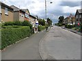
Chirnside Road
Long straight residential street running parallel with the railway which runs behind the houses on the left.
Image: © Richard Webb
Taken: 16 Jun 2009
0.18 miles
2
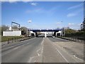
Rebuilt railway bridge
Last time I was here, in 2009 the bridge was being rebuilt. Image
Image: © Richard Webb
Taken: 9 Apr 2013
0.19 miles
3
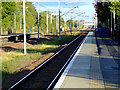
Hillington West railway station
Looking up the line towards Hillington East station.
Image: © Thomas Nugent
Taken: 25 Sep 2010
0.21 miles
4
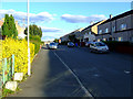
Linburn Road
Looking east from the lane at Hillington West railway station.
Image: © Thomas Nugent
Taken: 25 Sep 2010
0.24 miles