IMAGES TAKEN NEAR TO
Paisley Road West, GLASGOW, G52 3TP
Introduction
This page details the photographs taken nearby to Paisley Road West, G52 3TP by members of the Geograph project.
The Geograph project started in 2005 with the aim of publishing, organising and preserving representative images for every square kilometre of Great Britain, Ireland and the Isle of Man.

There are currently over 7.5m images from over14,400 individuals and you can help contribute to the project by visiting https://www.geograph.org.uk
Image Map
Images are licensed for reuse under creativecommons.org/licenses/by-sa/2.0
Notes
- Clicking on the map will re-center to the selected point.
- The higher the marker number, the further away the image location is from the centre of the postcode.
Image Listing (41 Images Found)
Images are licensed for reuse under creativecommons.org/licenses/by-sa/2.0
Image
Details
Distance
2
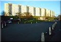
Housing in Montrave Street Cardonald
The flats in the background are Moss Heights, 1953, the first high rise flats to be built in Glasgow.
Image: © David McMumm
Taken: 2 Mar 2011
0.07 miles
3
Moss Heights seen from Dyke Hill, south of Barrhead
Even from over 9km away, the distinctive outline of the Moss Heights flats [http://www.geograph.org.uk/photo/5313999] stands out clearly.
Image: © Richard Sutcliffe
Taken: 18 Jul 2017
0.08 miles
4
Moss Heights on Mossheights Avenue
The first multistorey flats built in Glasgow, in 1949. Berryknowes Avenue is in the foreground.
Image: © Richard Sutcliffe
Taken: 16 Mar 2017
0.08 miles
5
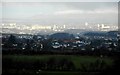
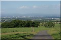
View over Glasgow
The earlier clouds have disappeared, and Glasgow is bathed in sunshine. The row of Mossheights flats stand out in the middle distance, 10km away; and there is snow on the Campsie Fells in the far distance. Seen from Caulders Braidbar Garden Centre Image
Image: © Richard Sutcliffe
Taken: 9 Jan 2020
0.08 miles
6
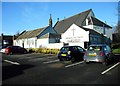
Hillington Park Parish Church
The original church, now the present church's Large Hall, was opened for worship in 1908. The current church (the larger building behind, able to seat over 500 people) opened in 1925.
Image: © Richard Sutcliffe
Taken: 17 Jan 2019
0.09 miles
7
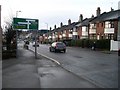
Road sign on approach to Paisley Road West
Approaching the crossroads with Berryknowes Road.
Image: © Stephen Sweeney
Taken: 4 Mar 2009
0.09 miles
8
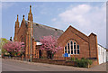
Hillington Park Parish Church
Situated on Berryknowes Road (A739), Cardonald
Image: © wfmillar
Taken: 19 Apr 2011
0.09 miles
9
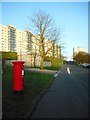
Berryknowes Avenue
Looking east, the Moss Heights flats dominate the view. The pillar box is postbox number G52 1314D [http://www.geograph.org.uk/photo/5314093].
Image: © Richard Sutcliffe
Taken: 16 Mar 2017
0.09 miles
10
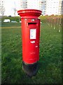
Pillar box, Berryknowes Avenue
Postbox number G52 1314D.
Image: © Richard Sutcliffe
Taken: 16 Mar 2017
0.09 miles