IMAGES TAKEN NEAR TO
Dundee Path, GLASGOW, G52 3RP
Introduction
This page details the photographs taken nearby to Dundee Path, G52 3RP by members of the Geograph project.
The Geograph project started in 2005 with the aim of publishing, organising and preserving representative images for every square kilometre of Great Britain, Ireland and the Isle of Man.

There are currently over 7.5m images from over14,400 individuals and you can help contribute to the project by visiting https://www.geograph.org.uk
Image Map
Images are licensed for reuse under creativecommons.org/licenses/by-sa/2.0
Notes
- Clicking on the map will re-center to the selected point.
- The higher the marker number, the further away the image location is from the centre of the postcode.
Image Listing (19 Images Found)
Images are licensed for reuse under creativecommons.org/licenses/by-sa/2.0
Image
Details
Distance
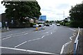
2
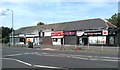
Local shops
On Mosspark Drive, Cardonald.
Image: © Richard Sutcliffe
Taken: 24 Aug 2019
0.05 miles
3
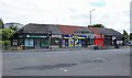
Shops on Mosspark Drive
Cardonald Smiles (dentist), Sun City (Chinese takeaway), Roy's (Keystore Express convenience store), Baxter's Cafe, 7 Spices (tandoori takeaway), itri Gelato Cravings (ice cream & desserts), Day-Today express (convenience store).
Image: © Richard Sutcliffe
Taken: 12 Jul 2024
0.06 miles
4
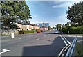
Mosspark Drive
Looking towards Glasgow Clyde College.
Image: © Richard Sutcliffe
Taken: 24 Aug 2019
0.06 miles
5
Mosspark Drive
Looking towards Glasgow Clyde College.
Image: © Richard Sutcliffe
Taken: 12 Jul 2024
0.06 miles
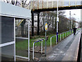
6
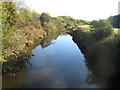
White Cart Water at South Cardonald
Looking up-river from the footbridge over the river beside Mosspark railway station.
Image: © G Laird
Taken: 4 Nov 2013
0.08 miles
7
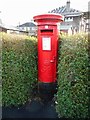
George V pillar box
Postbox number G52 933D at the junction of Kirriemuir Avenue and Mosspark Drive. The house behind is being re-roofed.
Image: © Richard Sutcliffe
Taken: 24 Feb 2017
0.10 miles
8
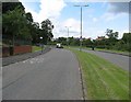
Linthaugh Road
Like many residential streets in Pollok, a dual carriageway, although restricted by chicanes and camera wielding cyclists. The street carries National Cycle Routes 7 and 75, a rare case of Sustrans seeking out a dual carriageway.
Image: © Richard Webb
Taken: 16 Jun 2009
0.12 miles
9
Mosspark railway station
On the Paisley Canal Line, between Corkerhill and Crookston.
Image: © Thomas Nugent
Taken: 8 Dec 2012
0.13 miles
10
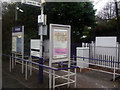
Mosspark railway station
On the Paisley Canal Line, between Corkerhill and Crookston.
Image: © Thomas Nugent
Taken: 8 Dec 2012
0.13 miles