IMAGES TAKEN NEAR TO
Cairnhill Drive, GLASGOW, G52 3LQ
Introduction
This page details the photographs taken nearby to Cairnhill Drive, G52 3LQ by members of the Geograph project.
The Geograph project started in 2005 with the aim of publishing, organising and preserving representative images for every square kilometre of Great Britain, Ireland and the Isle of Man.

There are currently over 7.5m images from over14,400 individuals and you can help contribute to the project by visiting https://www.geograph.org.uk
Image Map
Images are licensed for reuse under creativecommons.org/licenses/by-sa/2.0
Notes
- Clicking on the map will re-center to the selected point.
- The higher the marker number, the further away the image location is from the centre of the postcode.
Image Listing (24 Images Found)
Images are licensed for reuse under creativecommons.org/licenses/by-sa/2.0
Image
Details
Distance
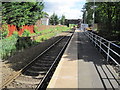
1
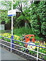
Crookston railway station
A brightly coloured locomotive themed planter made of wooden barrels.
Image: © Thomas Nugent
Taken: 18 May 2013
0.02 miles
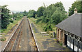
2
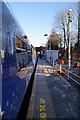
Crookston railway station
On the recently electrified Paisley Canal line.
See the same scene in March 2009 Image
Image: © Thomas Nugent
Taken: 1 Dec 2012
0.03 miles
3
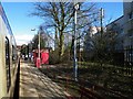
Crookston railway station
Viewed from a west bound train.
Image: © Thomas Nugent
Taken: 21 Mar 2009
0.04 miles
4
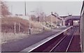
Crookston railway station, Glasgow
Opened in 1885 by the Glasgow & South Western Railway on its line from Glasgow to Elderslie via Paisley Canal, this station closed in 1983. The line and station were then reopened in 1990 but only with a single track, leaving this platform redundant. Taken from a train departing for Kilmacolm. See Image] for a more recent view.
Image: © Nigel Thompson
Taken: 8 Jan 1983
0.04 miles
5
Crookston railway station, Glasgow
Opened in 1885 by the Glasgow & South Western Railway on its line from Glasgow to Elderslie via Paisley Canal, this station closed in 1983. The line and station were then reopened in 1990 but only with a single track, leaving the opposite platform redundant. Taken shortly before the line was electrified.
Image: © Nigel Thompson
Taken: 28 Jul 2012
0.04 miles
6
Crookston station (remains), 1986
View westward, towards Paisley: ex-G&SW Glasgow St Enoch (Glasgow Central from 27/6/66) - Paisley Canal line. The station was closed from 10/1/83, but the line remained until c. 1987. The station and the line have been reopened for passengers from 27/7/90.
Image: © Ben Brooksbank
Taken: 6 Jul 1986
0.05 miles
7
Crookston railway station
On the recently electrified paisley Canal line.
Image: © Thomas Nugent
Taken: 1 Dec 2012
0.05 miles
8

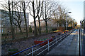
Rosshall Estate
Estate road near the hospital.
Image: © wfmillar
Taken: 19 Apr 2011
0.16 miles
9
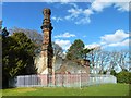
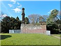
Rosshall Gardens: the old boiler house
Before the later Ross Hall (now Image) was built nearby, there was a building here. It is shown on the first-edition OS map (surveyed in 1858), where it is called Rosshill.
Ross Hall was built for James Cowan (Image) in 1877. It had a glasshouse attached to it, but glasshouses were also built alongside this earlier building, Rosshill.
According to notice boards near the western entrance to Rosshall Park, Rosshill came to be used as a boiler house. The presence of a chimney here is noted on the map revision of c.1934, but not on that of c.1909. As the picture shows, the material of the chimney is quite different from that of the corner of the building on which it stands.
See Image for another view.
Image: © Lairich Rig
Taken: 24 Mar 2014
0.18 miles
10
Rosshall Gardens: the old boiler house
This building was Rosshill, a house. In its role as the main house of the estate, it was superseded by Ross Hall (built in 1877 – Image). At some later time, the original building, Rosshill, was made a boiler house; the incongruous castellated chimney is a reminder of that use.
For another view, and for more information, see Image
Image: © Lairich Rig
Taken: 24 Mar 2014
0.18 miles