IMAGES TAKEN NEAR TO
Arbroath Avenue, GLASGOW, G52 3EZ
Introduction
This page details the photographs taken nearby to Arbroath Avenue, G52 3EZ by members of the Geograph project.
The Geograph project started in 2005 with the aim of publishing, organising and preserving representative images for every square kilometre of Great Britain, Ireland and the Isle of Man.

There are currently over 7.5m images from over14,400 individuals and you can help contribute to the project by visiting https://www.geograph.org.uk
Image Map
Images are licensed for reuse under creativecommons.org/licenses/by-sa/2.0
Notes
- Clicking on the map will re-center to the selected point.
- The higher the marker number, the further away the image location is from the centre of the postcode.
Image Listing (22 Images Found)
Images are licensed for reuse under creativecommons.org/licenses/by-sa/2.0
Image
Details
Distance
1
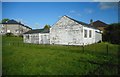
Labour Rooms, 996 Mosspark Drive
Used by the local Labour councillor to conduct regular monthly surgeries for constituents in Cardonald. The building is desperately in need of a re-paint.
Image: © Richard Sutcliffe
Taken: 9 May 2017
0.13 miles
2

Empty site
The site of a former wooden building, used as Labour Rooms, at 996 Mosspark Drive [https://www.geograph.org.uk/photo/5384033], which was demolished in May 2019.
Image: © Richard Sutcliffe
Taken: 28 May 2019
0.13 miles
3

Cardonald Library
The Library offers a wide range of services and activities. The building first opened in 1970, and is today run by Glasgow Life on behalf of Glasgow City Council.
Image: © Richard Sutcliffe
Taken: 17 Jan 2019
0.13 miles
4

Yes and No, Paisley Road West, Glasgow
Photographed on the day of the Scottish Independence Referendum, 18th September 2014. One 'Yes', one 'No'.
Image: © Richard Sutcliffe
Taken: 18 Sep 2014
0.17 miles
5
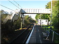
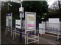
Mosspark Railway Station
The station between Crookston and Corkerhill on the Paisley Canal Line.
Image: © G Laird
Taken: 4 Nov 2013
0.17 miles
6
Mosspark railway station, Glasgow
Opened in 1934 by the London Midland & Scottish Railway on its line from Glasgow to Elderslie via Paisley Canal, this station closed in 1983 and then reopened in 1990 with the line. Taken just before the line was electrified.
Image: © Nigel Thompson
Taken: 28 Jul 2012
0.18 miles
7
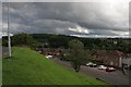
Dundee Drive
Looking down on Dundee Drive from Angus Oval. The woodland on the horizon is Crookston Wood.
Image: © Richard Sutcliffe
Taken: 26 Aug 2015
0.18 miles
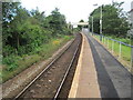
8
Mosspark railway station
On the Paisley Canal Line, between Corkerhill and Crookston.
Image: © Thomas Nugent
Taken: 8 Dec 2012
0.18 miles
9
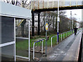
Mosspark railway station
On the Paisley Canal Line, between Corkerhill and Crookston.
Image: © Thomas Nugent
Taken: 8 Dec 2012
0.19 miles
10
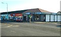
Greggs, Paisley Road West
The former Clydesdale Bank property was completely refurbished in 2018, including re-roofing. The bakery store offers eat-in and take-away services.
Image: © Richard Sutcliffe
Taken: 17 Jan 2019
0.19 miles