IMAGES TAKEN NEAR TO
Kirriemuir Avenue, GLASGOW, G52 3DF
Introduction
This page details the photographs taken nearby to Kirriemuir Avenue, G52 3DF by members of the Geograph project.
The Geograph project started in 2005 with the aim of publishing, organising and preserving representative images for every square kilometre of Great Britain, Ireland and the Isle of Man.

There are currently over 7.5m images from over14,400 individuals and you can help contribute to the project by visiting https://www.geograph.org.uk
Image Map (Loading...)


Getting Data...Please wait
Leaflet Map data © OpenStreetMap
Images are licensed for reuse under creativecommons.org/licenses/by-sa/2.0
Notes
- Clicking on the map will re-center to the selected point.
- The higher the marker number, the further away the image location is from the centre of the postcode.
Image Listing (45 Images Found)
Images are licensed for reuse under creativecommons.org/licenses/by-sa/2.0
Image
Details
Distance
1
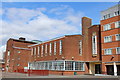
Lourdes Secondary School, South Cardonald, Glasgow
Built in the 1950s and extended in the 1970s
Image: © Leslie Barrie
Taken: 27 Apr 2013
0.03 miles
2
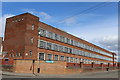
Lourdes Secondary School, South Cardonald, Glasgow
Built in the 1950s and extended in the 1970s
Image: © Leslie Barrie
Taken: 27 Apr 2013
0.06 miles
3
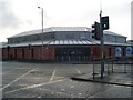
Cardonald Medical Centre
Local health care facility on Paisley Road West.
Image: © Stephen Sweeney
Taken: 4 Mar 2009
0.09 miles
4

The A761 to Paisley
At the junction with the A739 to the Clyde Tunnel on a very wet Wednesday.
Image: © Barbara Carr
Taken: 17 Apr 2013
0.12 miles
5
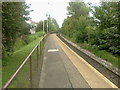
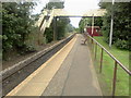
Mosspark railway station, looking ESE
View from single platform at Mosspark railway station, looking roughly ESE towards Glasgow Central.
Image: © Andrew Reid
Taken: 19 Aug 2011
0.12 miles
6
Mosspark railway station, looking WNW
View from single platform at Mosspark railway station, looking roughly WNW towards Paisley Canal.
Image: © Andrew Reid
Taken: 19 Aug 2011
0.12 miles

8
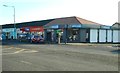
Greggs, Paisley Road West
The former Clydesdale Bank property was completely refurbished in 2018, including re-roofing. The bakery store offers eat-in and take-away services.
Image: © Richard Sutcliffe
Taken: 17 Jan 2019
0.14 miles
9
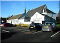
Hillington Park Parish Church
The original church, now the present church's Large Hall, was opened for worship in 1908. The current church (the larger building behind, able to seat over 500 people) opened in 1925.
Image: © Richard Sutcliffe
Taken: 17 Jan 2019
0.15 miles
10
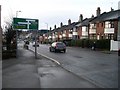
Road sign on approach to Paisley Road West
Approaching the crossroads with Berryknowes Road.
Image: © Stephen Sweeney
Taken: 4 Mar 2009
0.15 miles