IMAGES TAKEN NEAR TO
Bankfoot Road, GLASGOW, G52 2TE
Introduction
This page details the photographs taken nearby to Bankfoot Road, G52 2TE by members of the Geograph project.
The Geograph project started in 2005 with the aim of publishing, organising and preserving representative images for every square kilometre of Great Britain, Ireland and the Isle of Man.

There are currently over 7.5m images from over14,400 individuals and you can help contribute to the project by visiting https://www.geograph.org.uk
Image Map
Images are licensed for reuse under creativecommons.org/licenses/by-sa/2.0
Notes
- Clicking on the map will re-center to the selected point.
- The higher the marker number, the further away the image location is from the centre of the postcode.
Image Listing (22 Images Found)
Images are licensed for reuse under creativecommons.org/licenses/by-sa/2.0
Image
Details
Distance
2
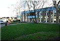
Cardonald Library
The Library offers a wide range of services and activities. The building first opened in 1970, and is today run by Glasgow Life on behalf of Glasgow City Council.
Image: © Richard Sutcliffe
Taken: 17 Jan 2019
0.13 miles
3

Yes and No, Paisley Road West, Glasgow
Photographed on the day of the Scottish Independence Referendum, 18th September 2014. One 'Yes', one 'No'.
Image: © Richard Sutcliffe
Taken: 18 Sep 2014
0.13 miles
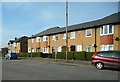
4
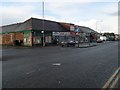
Paisley Road West shops
Opposite the Aldi's on the same road.
Image: © Stephen Sweeney
Taken: 4 Mar 2009
0.15 miles
5
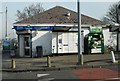
Shopsmart, Tweedsmuir Road
A corner shop at the junction of Tweedsmuir Road and Invergyle Drive.
Image: © Richard Sutcliffe
Taken: 24 Mar 2017
0.16 miles
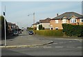
6
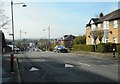
Tweedsmuir Road
Looking towards Paisley Road West in the distance.
Image: © Richard Sutcliffe
Taken: 24 Mar 2017
0.16 miles
7
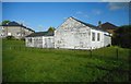
Labour Rooms, 996 Mosspark Drive
Used by the local Labour councillor to conduct regular monthly surgeries for constituents in Cardonald. The building is desperately in need of a re-paint.
Image: © Richard Sutcliffe
Taken: 9 May 2017
0.17 miles
9
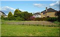
Empty site
The site of a former wooden building, used as Labour Rooms, at 996 Mosspark Drive [https://www.geograph.org.uk/photo/5384033], which was demolished in May 2019.
Image: © Richard Sutcliffe
Taken: 28 May 2019
0.17 miles
10
Dryburn Avenue
Seen from the junction with Tweedsmuir Road.
Image: © Richard Sutcliffe
Taken: 24 Mar 2017
0.19 miles