IMAGES TAKEN NEAR TO
Ranfurly Road, GLASGOW, G52 2RJ
Introduction
This page details the photographs taken nearby to Ranfurly Road, G52 2RJ by members of the Geograph project.
The Geograph project started in 2005 with the aim of publishing, organising and preserving representative images for every square kilometre of Great Britain, Ireland and the Isle of Man.

There are currently over 7.5m images from over14,400 individuals and you can help contribute to the project by visiting https://www.geograph.org.uk
Image Map (Loading...)


Getting Data...Please wait
Leaflet Map data © OpenStreetMap
Images are licensed for reuse under creativecommons.org/licenses/by-sa/2.0
Notes
- Clicking on the map will re-center to the selected point.
- The higher the marker number, the further away the image location is from the centre of the postcode.
Image Listing (24 Images Found)
Images are licensed for reuse under creativecommons.org/licenses/by-sa/2.0
Image
Details
Distance
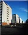
1
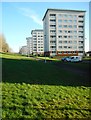
Blocks of flats, Kelhead Path
The blocks of flats at Kelhead Path and nearby Tinwald Path [https://www.geograph.org.uk/photo/6026803] were renovated about ten years ago. The work was implemented by Glasgow Housing Association (GHA) as part of a programme designed to modernise homes, making them warmer and drier [https://www.geograph.org.uk/photo/1188941].
Image: © Richard Sutcliffe
Taken: 17 Jan 2019
0.10 miles
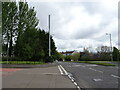
2
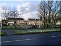
Sandwood Road houses
Looking across from Hillington Terrace.
Image: © Stephen Sweeney
Taken: 4 Mar 2009
0.10 miles
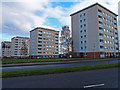
3
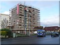
GHA redevelopment in Hillington
Flats being redeveloped in the area in Glasgow, by the Glasgow Housing Association.
Image: © Stephen Sweeney
Taken: 4 Mar 2009
0.11 miles
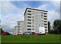
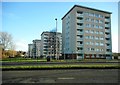
5
Blocks of flats, Kelhead Path
The blocks of flats at Kelhead Path and nearby Tinwald Path [https://www.geograph.org.uk/photo/6026803] were renovated about ten years ago. The work was implemented by Glasgow Housing Association (GHA) as part of a programme designed to modernise homes, making them warmer and drier [https://www.geograph.org.uk/photo/1188941].
Image: © Richard Sutcliffe
Taken: 17 Jan 2019
0.13 miles
7
Flats, Hillington
Flats at Tinwald Path. Looks like there has been an incident at the furthest away block.
Image: © wfmillar
Taken: 4 Nov 2011
0.15 miles

9
Blocks of flats, Tinwald Path
Seen from beside the A736, Sandwood Road.
Image: © Richard Sutcliffe
Taken: 17 Jan 2019
0.16 miles
10
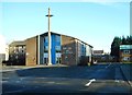
Church of Our Lady & St George, Penilee
The Roman Catholic church on Sandwood Road opened in 1959.
Image: © Richard Sutcliffe
Taken: 17 Jan 2019
0.17 miles