IMAGES TAKEN NEAR TO
Corkerhill Place, GLASGOW, G52 1RZ
Introduction
This page details the photographs taken nearby to Corkerhill Place, G52 1RZ by members of the Geograph project.
The Geograph project started in 2005 with the aim of publishing, organising and preserving representative images for every square kilometre of Great Britain, Ireland and the Isle of Man.

There are currently over 7.5m images from over14,400 individuals and you can help contribute to the project by visiting https://www.geograph.org.uk
Image Map
Images are licensed for reuse under creativecommons.org/licenses/by-sa/2.0
Notes
- Clicking on the map will re-center to the selected point.
- The higher the marker number, the further away the image location is from the centre of the postcode.
Image Listing (46 Images Found)
Images are licensed for reuse under creativecommons.org/licenses/by-sa/2.0
Image
Details
Distance
1
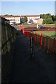
Path and bollard, Corkerhill
Path leading past play area down to Corkerhill Place.
Image: © Richard Sutcliffe
Taken: 10 Sep 2015
0.02 miles
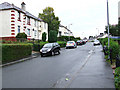
2
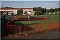
Play park, Corkerhill
Play area and houses at Corkerhill Place. The area at top right is the Dennis Donnelly Park, used as a pitch by Pollok United Football Academy.
Image: © Richard Sutcliffe
Taken: 10 Sep 2015
0.08 miles
3
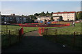
Play park, Corkerhill
Play park between Hardridge Road and the M77 motorway. The houses in the background are on Corkerhill Place.
Image: © Richard Sutcliffe
Taken: 10 Sep 2015
0.08 miles
4
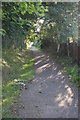
Footpath beside M77
It's hard to believe the M77 is just out of view to the left of the path.
Image: © Richard Sutcliffe
Taken: 10 Sep 2015
0.08 miles
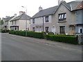
5
Aros Drive
Near the east end of Ascaig Crescent.
Image: © Thomas Nugent
Taken: 19 Oct 2013
0.12 miles
7

Aros Drive
Twenty's plenty on this road, according to the road markings.
Image: © Thomas Nugent
Taken: 19 Oct 2013
0.13 miles
8

Approaching overbridge at Corkerhill on M77
Image: © John Firth
Taken: 15 May 2014
0.14 miles
9
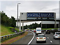
Sign Gantry at Junction 2 of the M77
A typical “Glasgow-type” sign gantry over the westbound carriageway of the M77, approaching Junction 2.
Gantries of this type were first erected as part of the construction of the Kingston Bridge and its approach roads in 1970 and they are now a familiar sight on the motorway network around Glasgow. They have the following distinctive elements:
• near and offside support legs (basically 2 rectangular hollow sections with base plates to allow connections to the foundations),
• a main frame (made up of rectangular hollow sections) - Over clad on the front and rear,
• a sub frame (made up of smaller hollow sections and welded to the main frame),
• a sign face - acrylic sheets hung from the front of the sub frame over its full height,
• internal electrics - sign lighting provided through the use of several dozen fluorescent battens.
More information on “Glasgow Style Gantries” at https://web.archive.org/web/20141106003519/http://www.glasgows-motorways.co.uk/glasgow-gantries/4578281645
(Glasgow’s Motorways, archived November 2014)
Image: © David Dixon
Taken: 24 Sep 2019
0.15 miles
10
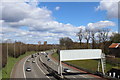
M77 at the farm of Corkerhill, Glasgow
Image: © Leslie Barrie
Taken: 27 Apr 2013
0.15 miles