IMAGES TAKEN NEAR TO
Bogmoor Road, GLASGOW, G51 4SQ
Introduction
This page details the photographs taken nearby to Bogmoor Road, G51 4SQ by members of the Geograph project.
The Geograph project started in 2005 with the aim of publishing, organising and preserving representative images for every square kilometre of Great Britain, Ireland and the Isle of Man.

There are currently over 7.5m images from over14,400 individuals and you can help contribute to the project by visiting https://www.geograph.org.uk
Image Map
Images are licensed for reuse under creativecommons.org/licenses/by-sa/2.0
Notes
- Clicking on the map will re-center to the selected point.
- The higher the marker number, the further away the image location is from the centre of the postcode.
Image Listing (25 Images Found)
Images are licensed for reuse under creativecommons.org/licenses/by-sa/2.0
Image
Details
Distance
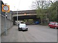
1
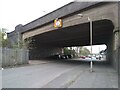
Motorway bridge
The bridge carries eight lanes (plus two hard shoulders) of the M8 motorway over Bogmoor Road.
Image: © Richard Sutcliffe
Taken: 26 Apr 2021
0.06 miles
2
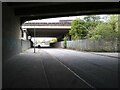
Under the bridges
Looking along Bogmoor Road. The bridge in the distance carries the M8 motorway over it. Photographed from under the bridge carrying the A8 (Shieldhall Road) over the road.
Image: © Richard Sutcliffe
Taken: 26 Apr 2021
0.06 miles
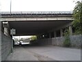
4
Bridge over Bogmoor Road
The bridge carries the A8 dual carriageway (Shieldhall Road) over Bogmoor Road.
Image: © Richard Sutcliffe
Taken: 26 Apr 2021
0.07 miles
5
Bridge over Bogmoor Road
The bridge carries the A8 dual carriageway (Shieldhall Road) over Bogmoor Road.
Image: © Richard Sutcliffe
Taken: 26 Apr 2021
0.09 miles
6
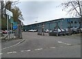
Shieldhall Recycling Centre
This is the staff entrance, off Bogmoor Road.
Image: © Richard Sutcliffe
Taken: 26 Apr 2021
0.12 miles
8

Vacant ground, Shieldhall
This area of vacant ground beside Hardgate Road is slowly being taken over by birch scrub. The building in the distance is Barclay & Mathieson Ltd (steel stockholder and distributor) Image
Image: © Richard Sutcliffe
Taken: 26 Apr 2021
0.14 miles
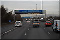
9
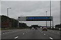
Glasgow-Style Sign Gantry on the M8
A typical “Glasgow-type” sign gantry approaching Junction 25A of the M8 near Braehead. Gantries of this type were first erected as part of the construction of the Kingston Bridge and its approach roads in 1970 and they are now a familiar sight on the network around Glasgow. They have the following distinctive elements:
• near and offside support legs (basically 2 rectangular hollow sections with base plates to allow connections to the foundations),
• a Main Frame (made up of rectangular hollow sections) - Over clad on the front and rear,
• a Sub Frame (made up of smaller hollow sections and welded to main frame),
• a Sign Face - acrylic sheets hung from the front of the sub frame over its full height,
• internal Electrics - sign lighting provided through the use of several dozen fluorescent battens.
More information on “Glasgow Style Gantries” at http://www.glasgows-motorways.co.uk/glasgow-gantries/4578281645 (Glasgow’s Motorways)
Image: © David Dixon
Taken: 24 Mar 2014
0.15 miles
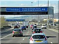
10
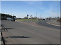
Roundabout on the A8
Looking up Renfrew Road towards the A8. The A8 runs from left to right at the top of the photograph while the road sharp right leads down to the Braehead shopping centre.
Image: © G Laird
Taken: 2 Apr 2010
0.19 miles